Saint-Claude geodata
Saint-Claude (Bourgogne-Franche-Comté) is a seat of a third-order administrative division; located in France in Europe/Paris (GMT+2) time zone. With population of 12,418 people, there are 767 cities with bigger population in this country. Compared to other cities in France, 61.2% of cities are located further ↑North; 85.7% of cities are located further ←West and 90.7% of cities have lower elevation than Saint-Claude. Note1
Administrative division(s):
- Level 1: Bourgogne-Franche-Comté
- Level 2: Jura
- Level 3: Arrondissement de Saint-Claude
- Level 4: Saint-Claude


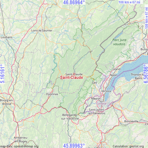
Saint-Claude GPS coordinates[2]
46° 23' 12.444" North, 5° 51' 53.028" East
| Map corner | latitude | longitude |
|---|---|---|
| Upper-left | 46.86964°, | 5.16161° |
| Center: | 46.38679°, | 5.86473° |
| Lower-right: | 45.89963°, | 6.56786° |
| Map W x H: | 107.9×107.9 km | = 67×67mi |
| max Lat: | 51.07786° ⇑61.2% North |
| Saint-Claude: | 46.38679° |
| min Lat: | ⇓38.8% South 41.3874° |
| min Long | Saint-Claude | max Long |
| -5.08615° | 5.86473° | 9.52242° |
| W 85.7%⇐ | ⇒14.3% E |
Elevation
Elevation of Saint-Claude is 442 m = 1450 ft, and this is 248.3 m = 815 ft above average elevation for this country.
| Max E: |
2333 m = 7654 ft | 9.3% |
| Saint-Claude | 442 m 1450 ft | |
| Avg. | 193.7 m = 635 ft | |
Min E: |
-1 m = -3 ft | 90.7% |
See also: France elevation on elevation.city.
Geographical zone
Saint-Claude is located in North temperate zone (between Tropic of Cancer and the Arctic Circle). Distance of this North polar circle is 2243.4 km =1394 mi to North.| Distance of | km | miles | from Saint-Claude |
|---|---|---|---|
| North Pole | 4849.3 | 3013.2 | to North |
| Arctic Circle | 2243.4 | 1394 | to North |
| Tropic Cancer | 2551.8 | 1585.6 | to South |
| Equator | 5157.7 | 3204.8 | to South |


Nearby cities:
15 places around Saint-Claude: (largest is in red/bold)
• Chassal
7 km =4.3 mi,  241°
241°
• Gex
16 km =9.9 mi,  111°
111°
• Lavans-lès-Saint-Claude
6.4 km =4 mi,  268°
268°
• Longchaumois
9.8 km =6.1 mi,  30°
30°
• Moirans-en-Montagne
11.8 km =7.3 mi,  296°
296°
• Molinges
8.4 km =5.2 mi,  245°
245°
• Pratz
7.9 km =4.9 mi,  262°
262°
• Prémanon
14.5 km =9 mi,  54°
54°
• Saint-Lupicin
5.8 km =3.6 mi,  285°
285°
• Septmoncel
4.1 km =2.5 mi, 114°
• Valfin-lès-Saint-Claude
5.7 km =3.5 mi,  352°
352°
• Vaux-lès-Saint-Claude
10.3 km =6.4 mi, 251°
• Villard-Saint-Sauveur
3 km =1.9 mi,  184°
184°
• Viry
13.8 km =8.6 mi,  225°
225°
• Échenevex
16 km =9.9 mi,  122°
122°
Sources, notices
• [Note1] Compared only with cities in France existing in our database
• [Src1] Map data: © OpenStreetMap contributors (CC-BY-SA)
• [Src2] Other city data from geonames.org with taken over terms of usage.
• [Src3] Geographical zone / Annual Mean Temperature by Robert A. Rohde @ Wikipedia
