Montreux-Château geodata
Montreux-Château (Bourgogne-Franche-Comté) is a populated place; located in France in Europe/Paris (GMT+2) time zone. With population of 1,016 people, there are 8720 cities with bigger population in this country. Compared to other cities in France, 52.8% of cities are located further ↓South; 94.8% of cities are located further ←West and 84.7% of cities have lower elevation than Montreux-Château. Note1
Administrative division(s):
- Level 1: Bourgogne-Franche-Comté
- Level 2: Territoire de Belfort
- Level 3: Arrondissement de Belfort
- Level 4: Montreux-Château


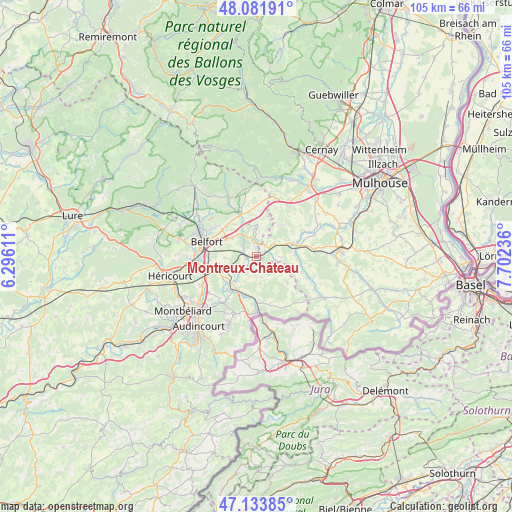
Montreux-Château GPS coordinates[2]
47° 36' 36.108" North, 6° 59' 57.228" East
| Map corner | latitude | longitude |
|---|---|---|
| Upper-left | 48.08191°, | 6.29611° |
| Center: | 47.61003°, | 6.99923° |
| Lower-right: | 47.13385°, | 7.70236° |
| Map W x H: | 105.4×105.4 km | = 65.5×65.5mi |
| max Lat: | 51.07786° ⇑47.2% North |
| Montreux-Château: | 47.61003° |
| min Lat: | ⇓52.8% South 41.3874° |
| min Long | Montreux-Châte | max Long |
| -5.08615° | 6.99923° | 9.52242° |
| W 94.8%⇐ | ⇒5.2% E |
Elevation
Elevation of Montreux-Château is 342 m = 1122 ft, and this is 148.3 m = 487 ft above average elevation for this country.
| Max E: |
2333 m = 7654 ft | 15.3% |
| Montreux-Château | 342 m 1122 ft | |
| Avg. | 193.7 m = 635 ft | |
Min E: |
-1 m = -3 ft | 84.7% |
See also: France elevation on elevation.city.
Geographical zone
Montreux-Château is located in North temperate zone (between Tropic of Cancer and the Arctic Circle). Distance of this North polar circle is 2107.4 km =1309.5 mi to North.| Distance of | km | miles | from Montreux-Château |
|---|---|---|---|
| North Pole | 4713.3 | 2928.7 | to North |
| Arctic Circle | 2107.4 | 1309.5 | to North |
| Tropic Cancer | 2687.8 | 1670.1 | to South |
| Equator | 5293.7 | 3289.4 | to South |


Nearby cities:
15 places around Montreux-Château: (largest is in red/bold)
• Bessoncourt
6.4 km =4 mi,  307°
307°
• Bourogne
8.1 km =5 mi,  229°
229°
• Chèvremont
6.3 km =3.9 mi,  289°
289°
• Denney
8.2 km =5.1 mi, 312°
• Fontaine
5.7 km =3.5 mi,  0°
0°
• Foussemagne
2.9 km =1.8 mi,  8°
8°
• Grandvillars
8.1 km =5 mi,  195°
195°
• Manspach
8 km =5 mi,  83°
83°
• Meroux
7.7 km =4.8 mi,  257°
257°
• Montreux-Vieux
2 km =1.2 mi,  61°
61°
• Morvillars
8.4 km =5.2 mi,  215°
215°
• Pérouse
8.6 km =5.3 mi, 290°
• Retzwiller
7.5 km =4.7 mi,  71°
71°
• Roppe
8.9 km =5.5 mi,  317°
317°
• Vézelois
6.3 km =3.9 mi,  267°
267°
Sources, notices
• [Note1] Compared only with cities in France existing in our database
• [Src1] Map data: © OpenStreetMap contributors (CC-BY-SA)
• [Src2] Other city data from geonames.org with taken over terms of usage.
• [Src3] Geographical zone / Annual Mean Temperature by Robert A. Rohde @ Wikipedia
