Pérouse geodata
Pérouse (Bourgogne-Franche-Comté) is a populated place; located in France in Europe/Paris (GMT+2) time zone. With population of 941 people, there are 9290 cities with bigger population in this country. Compared to other cities in France, 53.3% of cities are located further ↓South; 94.2% of cities are located further ←West and 86.6% of cities have lower elevation than Pérouse. Note1
Administrative division(s):
- Level 1: Bourgogne-Franche-Comté
- Level 2: Territoire de Belfort
- Level 3: Arrondissement de Belfort
- Level 4: Pérouse


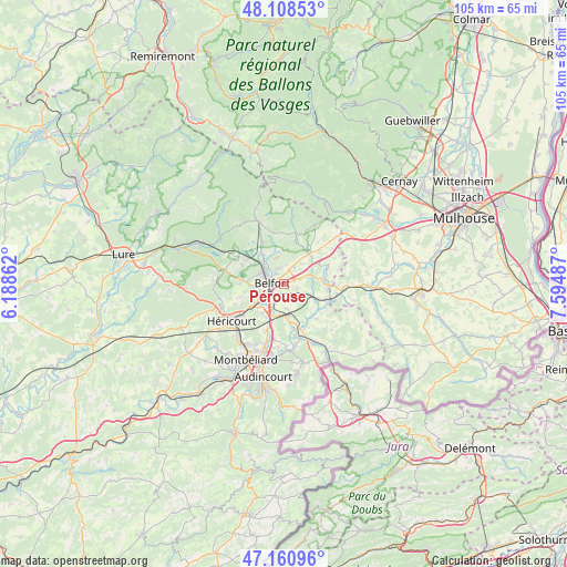
Pérouse GPS coordinates[2]
47° 38' 12.804" North, 6° 53' 30.264" East
| Map corner | latitude | longitude |
|---|---|---|
| Upper-left | 48.10853°, | 6.18862° |
| Center: | 47.63689°, | 6.89174° |
| Lower-right: | 47.16096°, | 7.59487° |
| Map W x H: | 105.4×105.4 km | = 65.5×65.5mi |
| max Lat: | 51.07786° ⇑46.7% North |
| Pérouse: | 47.63689° |
| min Lat: | ⇓53.3% South 41.3874° |
| min Long | Pérouse | max Long |
| -5.08615° | 6.89174° | 9.52242° |
| W 94.2%⇐ | ⇒5.8% E |
Elevation
Elevation of Pérouse is 368 m = 1207 ft, and this is 174.3 m = 572 ft above average elevation for this country.
| Max E: |
2333 m = 7654 ft | 13.4% |
| Pérouse | 368 m 1207 ft | |
| Avg. | 193.7 m = 635 ft | |
Min E: |
-1 m = -3 ft | 86.6% |
See also: France elevation on elevation.city.
Geographical zone
Pérouse is located in North temperate zone (between Tropic of Cancer and the Arctic Circle). Distance of this North polar circle is 2104.4 km =1307.6 mi to North.| Distance of | km | miles | from Pérouse |
|---|---|---|---|
| North Pole | 4710.3 | 2926.8 | to North |
| Arctic Circle | 2104.4 | 1307.6 | to North |
| Tropic Cancer | 2690.8 | 1672 | to South |
| Equator | 5296.7 | 3291.2 | to South |


Nearby cities:
15 places around Pérouse: (largest is in red/bold)
• Andelnans
4.3 km =2.7 mi,  206°
206°
• Bavilliers
4.5 km =2.8 mi,  249°
249°
• Belfort
2.9 km =1.8 mi,  281°
281°
• Bessoncourt
3.2 km =2 mi,  73°
73°
• Chèvremont
2.3 km =1.4 mi,  111°
111°
• Cravanche
4.8 km =3 mi,  292°
292°
• Danjoutin
3 km =1.9 mi,  226°
226°
• Denney
3.2 km =2 mi,  37°
37°
• Essert
5.6 km =3.5 mi,  266°
266°
• Meroux
4.6 km =2.9 mi,  173°
173°
• Offemont
3.1 km =1.9 mi,  339°
339°
• Roppe
4.2 km =2.6 mi,  29°
29°
• Sevenans
5.9 km =3.7 mi,  198°
198°
• Valdoie
5.3 km =3.3 mi,  315°
315°
• Vézelois
3.7 km =2.3 mi,  151°
151°
Sources, notices
• [Note1] Compared only with cities in France existing in our database
• [Src1] Map data: © OpenStreetMap contributors (CC-BY-SA)
• [Src2] Other city data from geonames.org with taken over terms of usage.
• [Src3] Geographical zone / Annual Mean Temperature by Robert A. Rohde @ Wikipedia
