Meroux geodata
Meroux (Bourgogne-Franche-Comté) is a populated place; located in France in Europe/Paris (GMT+2) time zone. With population of 689 people, there are 11953 cities with bigger population in this country. Compared to other cities in France, 52.6% of cities are located further ↓South; 94.3% of cities are located further ←West and 86.2% of cities have lower elevation than Meroux. Note1
Administrative division(s):
- Level 1: Bourgogne-Franche-Comté
- Level 2: Territoire de Belfort
- Level 3: Arrondissement de Belfort
- Level 4: Meroux-Moval


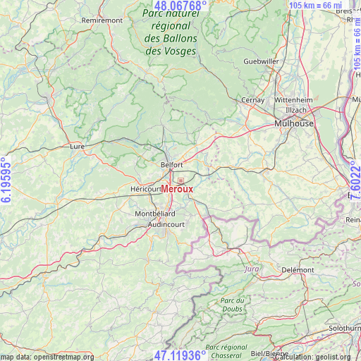
Meroux GPS coordinates[2]
47° 35' 44.412" North, 6° 53' 56.652" East
| Map corner | latitude | longitude |
|---|---|---|
| Upper-left | 48.06768°, | 6.19595° |
| Center: | 47.59567°, | 6.89907° |
| Lower-right: | 47.11936°, | 7.6022° |
| Map W x H: | 105.4×105.4 km | = 65.5×65.5mi |
| max Lat: | 51.07786° ⇑47.4% North |
| Meroux: | 47.59567° |
| min Lat: | ⇓52.6% South 41.3874° |
| min Long | Meroux | max Long |
| -5.08615° | 6.89907° | 9.52242° |
| W 94.3%⇐ | ⇒5.7% E |
Elevation
Elevation of Meroux is 362 m = 1188 ft, and this is 168.3 m = 552 ft above average elevation for this country.
| Max E: |
2333 m = 7654 ft | 13.8% |
| Meroux | 362 m 1188 ft | |
| Avg. | 193.7 m = 635 ft | |
Min E: |
-1 m = -3 ft | 86.2% |
See also: France elevation on elevation.city.
Geographical zone
Meroux is located in North temperate zone (between Tropic of Cancer and the Arctic Circle). Distance of this North polar circle is 2109 km =1310.5 mi to North.| Distance of | km | miles | from Meroux |
|---|---|---|---|
| North Pole | 4714.9 | 2929.7 | to North |
| Arctic Circle | 2109 | 1310.5 | to North |
| Tropic Cancer | 2686.2 | 1669.1 | to South |
| Equator | 5292.1 | 3288.4 | to South |


Nearby cities:
15 places around Meroux: (largest is in red/bold)
• Allenjoie
6.8 km =4.2 mi,  181°
181°
• Andelnans
2.6 km =1.6 mi,  287°
287°
• Bavilliers
5.6 km =3.5 mi,  301°
301°
• Belfort
6.2 km =3.9 mi,  326°
326°
• Bessoncourt
6 km =3.7 mi,  24°
24°
• Bourogne
3.9 km =2.4 mi,  160°
160°
• Châtenois-les-Forges
5.6 km =3.5 mi,  222°
222°
• Chèvremont
4.1 km =2.5 mi, 23°
• Dambenois
6.1 km =3.8 mi,  202°
202°
• Danjoutin
3.7 km =2.3 mi,  312°
312°
• Dorans
4.6 km =2.9 mi,  260°
260°
• Morvillars
5.9 km =3.7 mi,  153°
153°
• Pérouse
4.6 km =2.9 mi,  353°
353°
• Sevenans
2.6 km =1.6 mi,  248°
248°
• Vézelois
1.8 km =1.1 mi,  41°
41°
Sources, notices
• [Note1] Compared only with cities in France existing in our database
• [Src1] Map data: © OpenStreetMap contributors (CC-BY-SA)
• [Src2] Other city data from geonames.org with taken over terms of usage.
• [Src3] Geographical zone / Annual Mean Temperature by Robert A. Rohde @ Wikipedia
