Montreuil-l'Argillé geodata
Montreuil-l'Argillé (Normandy) is a populated place; located in France in Europe/Paris (GMT+2) time zone. With population of 794 people, there are 10681 cities with bigger population in this country. Compared to other cities in France, 78.3% of cities are located further ↓South; 73.6% of cities are located further →East and 59.8% of cities have lower elevation than Montreuil-l'Argillé. Note1
Administrative division(s):
- Level 1: Normandy
- Level 2: Département de l'Eure
- Level 3: Arrondissement de Bernay
- Level 4: Montreuil-l'Argillé


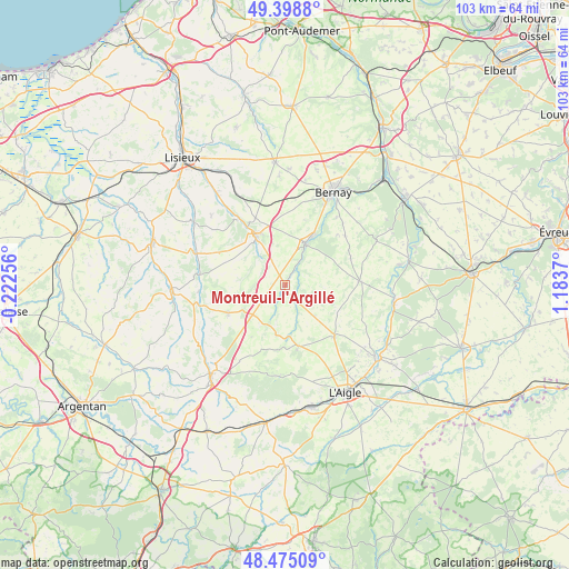
Montreuil-l'Argillé GPS coordinates[2]
48° 56' 20.688" North, 0° 28' 50.052" East
| Map corner | latitude | longitude |
|---|---|---|
| Upper-left | 49.3988°, | -0.22256° |
| Center: | 48.93908°, | 0.48057° |
| Lower-right: | 48.47509°, | 1.1837° |
| Map W x H: | 102.7×102.7 km | = 63.8×63.8mi |
| max Lat: | 51.07786° ⇑21.7% North |
| Montreuil-l'Argillé: | 48.93908° |
| min Lat: | ⇓78.3% South 41.3874° |
| min Long | Montreuil-l'Arg | max Long |
| -5.08615° | 0.48057° | 9.52242° |
| W 26.4%⇐ | ⇒73.6% E |
Elevation
Elevation of Montreuil-l'Argillé is 169 m = 554 ft, and this is 24.7 m = 81 ft below average elevation for this country.
| Max E: |
2333 m = 7654 ft | 40.2% |
| Avg. | 193.7 m = 635 ft | |
| Montreuil-l'Argillé | 169 m = 554 ft | |
Min E: |
-1 m = -3 ft | 59.8% |
See also: France elevation on elevation.city.
Geographical zone
Montreuil-l'Argillé is located in North temperate zone (between Tropic of Cancer and the Arctic Circle). Distance of this North polar circle is 1959.7 km =1217.7 mi to North.| Distance of | km | miles | from Montreuil-l'Argillé |
|---|---|---|---|
| North Pole | 4565.5 | 2836.9 | to North |
| Arctic Circle | 1959.7 | 1217.7 | to North |
| Tropic Cancer | 2835.6 | 1762 | to South |
| Equator | 5441.5 | 3381.2 | to South |


Nearby cities:
15 places around Montreuil-l'Argillé: (largest is in red/bold)
• Beaumesnil
18.3 km =11.4 mi,  63°
63°
• Broglie
8.6 km =5.3 mi,  24°
24°
• Caorches-Saint-Nicolas
16.8 km =10.4 mi, 17°
• Courtonne-les-Deux-Églises
18.1 km =11.2 mi,  332°
332°
• Glos-la-Ferrière
12.7 km =7.9 mi,  136°
136°
• La Barre-en-Ouche
13.5 km =8.4 mi,  86°
86°
• La Chapelle-Yvon
17.3 km =10.7 mi,  323°
323°
• La Ferté-Frênel
11.1 km =6.9 mi,  168°
168°
• La Vespière
10.3 km =6.4 mi, 331°
• Le Sap
11.5 km =7.1 mi,  244°
244°
• Orbec
9.8 km =6.1 mi, 331°
• Saint-Aubin-le-Vertueux
15.5 km =9.6 mi,  36°
36°
• Saint-Cyr-du-Ronceray
18.4 km =11.4 mi,  313°
313°
• Saint-Germain-la-Campagne
13.3 km =8.3 mi,  335°
335°
• Saint-Symphorien-des-Bruyères
18.3 km =11.4 mi,  156°
156°
Sources, notices
• [Note1] Compared only with cities in France existing in our database
• [Src1] Map data: © OpenStreetMap contributors (CC-BY-SA)
• [Src2] Other city data from geonames.org with taken over terms of usage.
• [Src3] Geographical zone / Annual Mean Temperature by Robert A. Rohde @ Wikipedia
