Le Sap geodata
Le Sap (Normandy) is a populated place; located in France in Europe/Paris (GMT+2) time zone. With population of 957 people, there are 9150 cities with bigger population in this country. Compared to other cities in France, 77.5% of cities are located further ↓South; 75% of cities are located further →East and 72.4% of cities have lower elevation than Le Sap. Note1
Administrative division(s):
- Level 1: Normandy
- Level 2: Département de l'Orne
- Level 3: Arrondissement de Mortagne-au-Perche
- Level 4: Sap-en-Auge


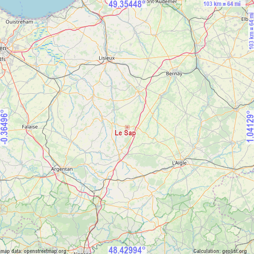
Le Sap GPS coordinates[2]
48° 53' 39.66" North, 0° 20' 17.412" East
| Map corner | latitude | longitude |
|---|---|---|
| Upper-left | 49.35448°, | -0.36496° |
| Center: | 48.89435°, | 0.33817° |
| Lower-right: | 48.42994°, | 1.04129° |
| Map W x H: | 102.8×102.8 km | = 63.9×63.9mi |
| max Lat: | 51.07786° ⇑22.5% North |
| Le Sap: | 48.89435° |
| min Lat: | ⇓77.5% South 41.3874° |
| min Long | Le Sap | max Long |
| -5.08615° | 0.33817° | 9.52242° |
| W 25%⇐ | ⇒75% E |
Elevation
Elevation of Le Sap is 232 m = 761 ft, and this is 38.3 m = 126 ft above average elevation for this country.
| Max E: |
2333 m = 7654 ft | 27.6% |
| Le Sap | 232 m 761 ft | |
| Avg. | 193.7 m = 635 ft | |
Min E: |
-1 m = -3 ft | 72.4% |
See also: France elevation on elevation.city.
Geographical zone
Le Sap is located in North temperate zone (between Tropic of Cancer and the Arctic Circle). Distance of this North polar circle is 1964.6 km =1220.7 mi to North.| Distance of | km | miles | from Le Sap |
|---|---|---|---|
| North Pole | 4570.5 | 2840 | to North |
| Arctic Circle | 1964.6 | 1220.7 | to North |
| Tropic Cancer | 2830.6 | 1758.9 | to South |
| Equator | 5436.5 | 3378.1 | to South |


Nearby cities:
15 places around Le Sap: (largest is in red/bold)
• Broglie
18.9 km =11.7 mi,  47°
47°
• Fervaques
17.4 km =10.8 mi,  339°
339°
• Gacé
11.6 km =7.2 mi,  195°
195°
• Glos-la-Ferrière
19.7 km =12.2 mi,  102°
102°
• La Chapelle-Yvon
18.8 km =11.7 mi,  0°
0°
• La Ferté-Frênel
13.9 km =8.6 mi,  114°
114°
• La Vespière
15 km =9.3 mi,  21°
21°
• Livarot
18.4 km =11.4 mi,  311°
311°
• Montreuil-l'Argillé
11.5 km =7.1 mi,  64°
64°
• Orbec
14.8 km =9.2 mi, 22°
• Saint-Cyr-du-Ronceray
17.9 km =11.1 mi,  350°
350°
• Saint-Germain-la-Campagne
17.8 km =11.1 mi, 16°
• Sainte-Gauburge-Sainte-Colombe
20.8 km =12.9 mi,  160°
160°
• Vimoutiers
10.9 km =6.8 mi,  289°
289°
• Échauffour
17.5 km =10.9 mi,  167°
167°
Sources, notices
• [Note1] Compared only with cities in France existing in our database
• [Src1] Map data: © OpenStreetMap contributors (CC-BY-SA)
• [Src2] Other city data from geonames.org with taken over terms of usage.
• [Src3] Geographical zone / Annual Mean Temperature by Robert A. Rohde @ Wikipedia
