La Barre-en-Ouche geodata
La Barre-en-Ouche (Normandy) is a populated place; located in France in Europe/Paris (GMT+2) time zone. With population of 896 people, there are 9692 cities with bigger population in this country. Compared to other cities in France, 78.5% of cities are located further ↓South; 71.7% of cities are located further →East and 65.8% of cities have lower elevation than La Barre-en-Ouche. Note1
Administrative division(s):
- Level 1: Normandy
- Level 2: Département de l'Eure
- Level 3: Arrondissement de Bernay
- Level 4: Mesnil-en-Ouche


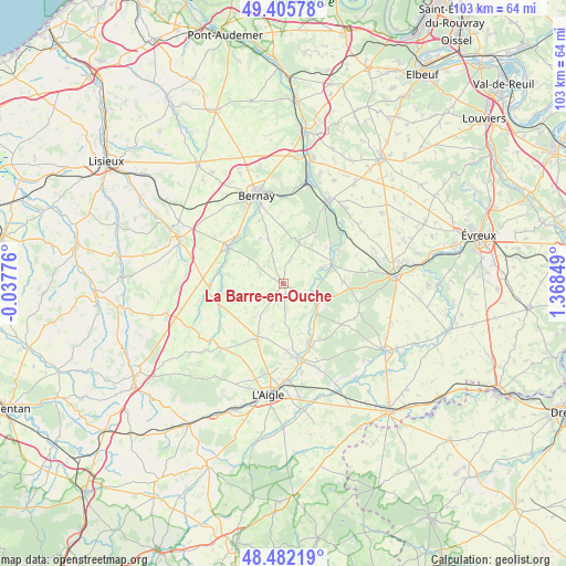
La Barre-en-Ouche GPS coordinates[2]
48° 56' 46.032" North, 0° 39' 55.296" East
| Map corner | latitude | longitude |
|---|---|---|
| Upper-left | 49.40578°, | -0.03776° |
| Center: | 48.94612°, | 0.66536° |
| Lower-right: | 48.48219°, | 1.36849° |
| Map W x H: | 102.7×102.7 km | = 63.8×63.8mi |
| max Lat: | 51.07786° ⇑21.5% North |
| La Barre-en-Ouche: | 48.94612° |
| min Lat: | ⇓78.5% South 41.3874° |
| min Long | La Barre-en-Ouc | max Long |
| -5.08615° | 0.66536° | 9.52242° |
| W 28.3%⇐ | ⇒71.7% E |
Elevation
Elevation of La Barre-en-Ouche is 198 m = 650 ft, and this is 4.3 m = 14 ft above average elevation for this country.
| Max E: |
2333 m = 7654 ft | 34.2% |
| La Barre-en-Ouche | 198 m 650 ft | |
| Avg. | 193.7 m = 635 ft | |
Min E: |
-1 m = -3 ft | 65.8% |
See also: France elevation on elevation.city.
Geographical zone
La Barre-en-Ouche is located in North temperate zone (between Tropic of Cancer and the Arctic Circle). Distance of this North polar circle is 1958.9 km =1217.2 mi to North.| Distance of | km | miles | from La Barre-en-Ouche |
|---|---|---|---|
| North Pole | 4564.8 | 2836.4 | to North |
| Arctic Circle | 1958.9 | 1217.2 | to North |
| Tropic Cancer | 2836.4 | 1762.5 | to South |
| Equator | 5442.3 | 3381.7 | to South |


Nearby cities:
15 places around La Barre-en-Ouche: (largest is in red/bold)
• Beaumesnil
7.8 km =4.8 mi,  22°
22°
• Beaumontel
16.8 km =10.4 mi, 24°
• Bernay
16.6 km =10.3 mi,  342°
342°
• Bois-Arnault
15.4 km =9.6 mi,  161°
161°
• Broglie
12.2 km =7.6 mi,  305°
305°
• Glos-la-Ferrière
11 km =6.8 mi,  205°
205°
• Grosley-sur-Risle
14.9 km =9.3 mi,  42°
42°
• La Ferté-Frênel
16.2 km =10.1 mi,  224°
224°
• La Neuve-Lyre
7.3 km =4.5 mi,  125°
125°
• La Vieille-Lyre
7 km =4.3 mi,  117°
117°
• Le Fidelaire
10.9 km =6.8 mi,  88°
88°
• Les Baux-de-Breteuil
13 km =8.1 mi, 124°
• Montreuil-l'Argillé
13.5 km =8.4 mi,  266°
266°
• Rugles
14.2 km =8.8 mi,  166°
166°
• Saint-Aubin-le-Vertueux
12.4 km =7.7 mi, 340°
Sources, notices
• [Note1] Compared only with cities in France existing in our database
• [Src1] Map data: © OpenStreetMap contributors (CC-BY-SA)
• [Src2] Other city data from geonames.org with taken over terms of usage.
• [Src3] Geographical zone / Annual Mean Temperature by Robert A. Rohde @ Wikipedia
