La Ferté-Frênel geodata
La Ferté-Frênel (Normandy) is a populated place; located in France in Europe/Paris (GMT+2) time zone. With population of 721 people, there are 11522 cities with bigger population in this country. Compared to other cities in France, 76.4% of cities are located further ↓South; 73.3% of cities are located further →East and 77.1% of cities have lower elevation than La Ferté-Frênel. Note1
Administrative division(s):
- Level 1: Normandy
- Level 2: Département de l'Orne
- Level 3: Arrondissement de Mortagne-au-Perche
- Level 4: La Ferté-en-Ouche


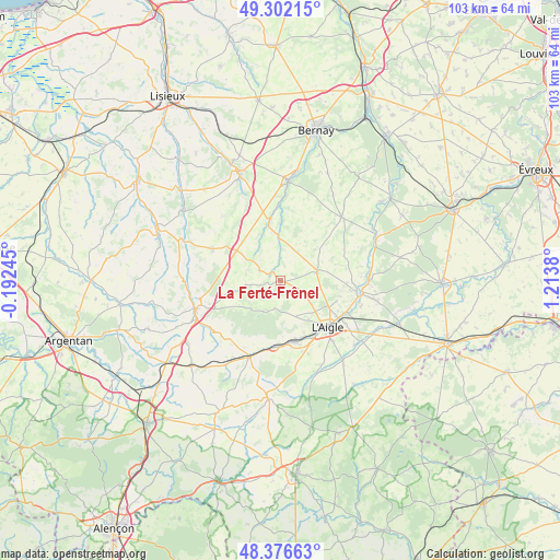
La Ferté-Frênel GPS coordinates[2]
48° 50' 29.508" North, 0° 30' 38.412" East
| Map corner | latitude | longitude |
|---|---|---|
| Upper-left | 49.30215°, | -0.19245° |
| Center: | 48.84153°, | 0.51067° |
| Lower-right: | 48.37663°, | 1.2138° |
| Map W x H: | 102.9×102.9 km | = 63.9×63.9mi |
| max Lat: | 51.07786° ⇑23.6% North |
| La Ferté-Frênel: | 48.84153° |
| min Lat: | ⇓76.4% South 41.3874° |
| min Long | La Ferté-Frên | max Long |
| -5.08615° | 0.51067° | 9.52242° |
| W 26.7%⇐ | ⇒73.3% E |
Elevation
Elevation of La Ferté-Frênel is 264 m = 866 ft, and this is 70.3 m = 231 ft above average elevation for this country.
| Max E: |
2333 m = 7654 ft | 22.9% |
| La Ferté-Frênel | 264 m 866 ft | |
| Avg. | 193.7 m = 635 ft | |
Min E: |
-1 m = -3 ft | 77.1% |
See also: France elevation on elevation.city.
Geographical zone
La Ferté-Frênel is located in North temperate zone (between Tropic of Cancer and the Arctic Circle). Distance of this North polar circle is 1970.5 km =1224.4 mi to North.| Distance of | km | miles | from La Ferté-Frênel |
|---|---|---|---|
| North Pole | 4576.4 | 2843.6 | to North |
| Arctic Circle | 1970.5 | 1224.4 | to North |
| Tropic Cancer | 2824.8 | 1755.2 | to South |
| Equator | 5430.7 | 3374.5 | to South |


Nearby cities:
15 places around La Ferté-Frênel: (largest is in red/bold)
• Aube-sur-Rîle
11.8 km =7.3 mi,  165°
165°
• Bois-Arnault
16.4 km =10.2 mi,  100°
100°
• Broglie
18.7 km =11.6 mi,  4°
4°
• Gacé
16.6 km =10.3 mi,  251°
251°
• Glos-la-Ferrière
6.8 km =4.2 mi,  75°
75°
• La Barre-en-Ouche
16.2 km =10.1 mi,  44°
44°
• Le Sap
13.9 km =8.6 mi,  294°
294°
• Montreuil-l'Argillé
11.1 km =6.9 mi,  348°
348°
• Rai
11.5 km =7.1 mi,  152°
152°
• Rugles
14.7 km =9.1 mi, 98°
• Saint-Ouen-sur-Iton
18 km =11.2 mi,  130°
130°
• Saint-Sulpice-sur-Risle
12.7 km =7.9 mi,  122°
122°
• Saint-Symphorien-des-Bruyères
7.9 km =4.9 mi,  138°
138°
• Sainte-Gauburge-Sainte-Colombe
15 km =9.3 mi,  202°
202°
• Échauffour
14.4 km =8.9 mi,  218°
218°
Sources, notices
• [Note1] Compared only with cities in France existing in our database
• [Src1] Map data: © OpenStreetMap contributors (CC-BY-SA)
• [Src2] Other city data from geonames.org with taken over terms of usage.
• [Src3] Geographical zone / Annual Mean Temperature by Robert A. Rohde @ Wikipedia
