Broglie geodata
Broglie (Normandy) is a populated place; located in France in Europe/Paris (GMT+2) time zone. With population of 1,190 people, there are 7594 cities with bigger population in this country. Compared to other cities in France, 79.8% of cities are located further ↓South; 73.1% of cities are located further →East and 54.5% of cities have lower elevation than Broglie. Note1
Administrative division(s):
- Level 1: Normandy
- Level 2: Département de l'Eure
- Level 3: Arrondissement de Bernay
- Level 4: Broglie


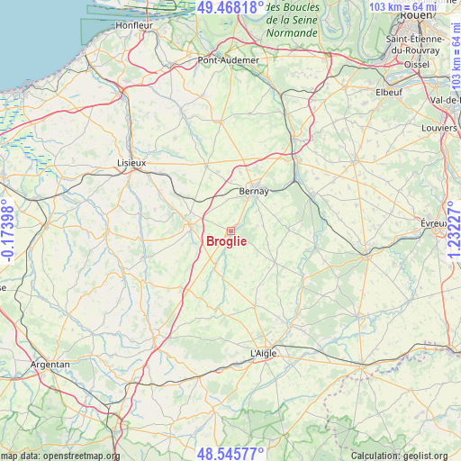
Broglie GPS coordinates[2]
49° 0' 32.796" North, 0° 31' 44.94" East
| Map corner | latitude | longitude |
|---|---|---|
| Upper-left | 49.46818°, | -0.17398° |
| Center: | 49.00911°, | 0.52915° |
| Lower-right: | 48.54577°, | 1.23227° |
| Map W x H: | 102.6×102.6 km | = 63.8×63.8mi |
| max Lat: | 51.07786° ⇑20.2% North |
| Broglie: | 49.00911° |
| min Lat: | ⇓79.8% South 41.3874° |
| min Long | Broglie | max Long |
| -5.08615° | 0.52915° | 9.52242° |
| W 26.9%⇐ | ⇒73.1% E |
Elevation
Elevation of Broglie is 148 m = 486 ft, and this is 45.7 m = 150 ft below average elevation for this country.
| Max E: |
2333 m = 7654 ft | 45.5% |
| Avg. | 193.7 m = 635 ft | |
| Broglie | 148 m = 486 ft | |
Min E: |
-1 m = -3 ft | 54.5% |
See also: France elevation on elevation.city.
Geographical zone
Broglie is located in North temperate zone (between Tropic of Cancer and the Arctic Circle). Distance of this North polar circle is 1951.9 km =1212.9 mi to North.| Distance of | km | miles | from Broglie |
|---|---|---|---|
| North Pole | 4557.8 | 2832.1 | to North |
| Arctic Circle | 1951.9 | 1212.9 | to North |
| Tropic Cancer | 2843.4 | 1766.8 | to South |
| Equator | 5449.3 | 3386 | to South |


Nearby cities:
15 places around Broglie: (largest is in red/bold)
• Beaumesnil
12.9 km =8 mi,  88°
88°
• Bernay
10.2 km =6.3 mi,  29°
29°
• Caorches-Saint-Nicolas
8.4 km =5.2 mi,  10°
10°
• Courbépine
13.3 km =8.3 mi, 10°
• Courtonne-les-Deux-Églises
14.4 km =8.9 mi,  304°
304°
• Drucourt
12.7 km =7.9 mi,  338°
338°
• La Barre-en-Ouche
12.2 km =7.6 mi,  125°
125°
• La Chapelle-Yvon
15.1 km =9.4 mi,  293°
293°
• La Vespière
8.6 km =5.3 mi,  277°
277°
• Menneval
11.9 km =7.4 mi, 32°
• Montreuil-l'Argillé
8.6 km =5.3 mi,  204°
204°
• Orbec
8.2 km =5.1 mi, 275°
• Saint-Aubin-le-Vertueux
7.4 km =4.6 mi,  50°
50°
• Saint-Germain-la-Campagne
10 km =6.2 mi, 295°
• Thiberville
15.3 km =9.5 mi, 339°
Sources, notices
• [Note1] Compared only with cities in France existing in our database
• [Src1] Map data: © OpenStreetMap contributors (CC-BY-SA)
• [Src2] Other city data from geonames.org with taken over terms of usage.
• [Src3] Geographical zone / Annual Mean Temperature by Robert A. Rohde @ Wikipedia
