Montpezat geodata
Montpezat (Nouvelle-Aquitaine) is a populated place; located in France in Europe/Paris (GMT+2) time zone. With population of 670 people, there are 12215 cities with bigger population in this country. Compared to other cities in France, 84.6% of cities are located further ↑North; 73.2% of cities are located further →East and 56.6% of cities have lower elevation than Montpezat. Note1
Administrative division(s):
- Level 1: Nouvelle-Aquitaine
- Level 2: Département du Lot-et-Garonne
- Level 3: Agen
- Level 4: Montpezat


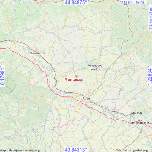
Montpezat GPS coordinates[2]
44° 20' 53.16" North, 0° 31' 23.556" East
| Map corner | latitude | longitude |
|---|---|---|
| Upper-left | 44.84875°, | -0.17991° |
| Center: | 44.3481°, | 0.52321° |
| Lower-right: | 43.84313°, | 1.22634° |
| Map W x H: | 111.8×111.8 km | = 69.5×69.5mi |
| max Lat: | 51.07786° ⇑84.6% North |
| Montpezat: | 44.3481° |
| min Lat: | ⇓15.4% South 41.3874° |
| min Long | Montpezat | max Long |
| -5.08615° | 0.52321° | 9.52242° |
| W 26.8%⇐ | ⇒73.2% E |
Elevation
Elevation of Montpezat is 156 m = 512 ft, and this is 37.7 m = 124 ft below average elevation for this country.
| Max E: |
2333 m = 7654 ft | 43.4% |
| Avg. | 193.7 m = 635 ft | |
| Montpezat | 156 m = 512 ft | |
Min E: |
-1 m = -3 ft | 56.6% |
See also: France elevation on elevation.city.
Geographical zone
Montpezat is located in North temperate zone (between Tropic of Cancer and the Arctic Circle). Distance of this Northern Tropic circle is 2325.1 km =1444.7 mi to South.| Distance of | km | miles | from Montpezat |
|---|---|---|---|
| North Pole | 5076 | 3154.1 | to North |
| Arctic Circle | 2470.1 | 1534.8 | to North |
| Tropic Cancer | 2325.1 | 1444.7 | to South |
| Equator | 4931 | 3064 | to South |


Nearby cities:
15 places around Montpezat: (largest is in red/bold)
• Allez-et-Cazeneuve
9.4 km =5.8 mi,  52°
52°
• Bazens
12.4 km =7.7 mi,  220°
220°
• Bourran
10.3 km =6.4 mi,  266°
266°
• Castelmoron-sur-Lot
6 km =3.7 mi,  338°
338°
• Clairac
11.5 km =7.1 mi,  276°
276°
• Dolmayrac
5.4 km =3.4 mi,  73°
73°
• Granges-sur-Lot
5.6 km =3.5 mi,  304°
304°
• Lafitte-sur-Lot
7.3 km =4.5 mi, 273°
• Laugnac
8 km =5 mi,  125°
125°
• Le Temple-sur-Lot
3.5 km =2.2 mi,  1°
1°
• Monclar
11.4 km =7.1 mi, 4°
• Pinel-Hauterive
10.2 km =6.3 mi,  26°
26°
• Prayssas
9.3 km =5.8 mi,  206°
206°
• Saint-Étienne-de-Fougères
8.2 km =5.1 mi,  17°
17°
• Sainte-Livrade-sur-Lot
7.8 km =4.8 mi,  43°
43°
Sources, notices
• [Note1] Compared only with cities in France existing in our database
• [Src1] Map data: © OpenStreetMap contributors (CC-BY-SA)
• [Src2] Other city data from geonames.org with taken over terms of usage.
• [Src3] Geographical zone / Annual Mean Temperature by Robert A. Rohde @ Wikipedia
