Granges-sur-Lot geodata
Granges-sur-Lot (Nouvelle-Aquitaine) is a populated place; located in France in Europe/Paris (GMT+2) time zone. With population of 562 people, there are 13969 cities with bigger population in this country. Compared to other cities in France, 84.4% of cities are located further ↑North; 73.7% of cities are located further →East and 85.3% of cities have higher elevation than Granges-sur-Lot. Note1
Administrative division(s):
- Level 1: Nouvelle-Aquitaine
- Level 2: Département du Lot-et-Garonne
- Level 3: Agen
- Level 4: Granges-sur-Lot


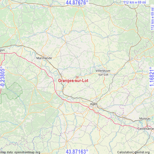
Granges-sur-Lot GPS coordinates[2]
44° 22' 34.86" North, 0° 27' 54.288" East
| Map corner | latitude | longitude |
|---|---|---|
| Upper-left | 44.87676°, | -0.23805° |
| Center: | 44.37635°, | 0.46508° |
| Lower-right: | 43.87163°, | 1.16821° |
| Map W x H: | 111.8×111.8 km | = 69.5×69.5mi |
| max Lat: | 51.07786° ⇑84.4% North |
| Granges-sur-Lot: | 44.37635° |
| min Lat: | ⇓15.6% South 41.3874° |
| min Long | Granges-sur-Lot | max Long |
| -5.08615° | 0.46508° | 9.52242° |
| W 26.3%⇐ | ⇒73.7% E |
Elevation
Elevation of Granges-sur-Lot is 41 m = 135 ft, and this is 152.7 m = 501 ft below average elevation for this country.
| Max E: |
2333 m = 7654 ft | 85.3% |
| Avg. | 193.7 m = 635 ft | |
| Granges-sur-Lot | 41 m = 135 ft | |
Min E: |
-1 m = -3 ft | 14.7% |
See also: France elevation on elevation.city.
Geographical zone
Granges-sur-Lot is located in North temperate zone (between Tropic of Cancer and the Arctic Circle). Distance of this Northern Tropic circle is 2328.3 km =1446.7 mi to South.| Distance of | km | miles | from Granges-sur-Lot |
|---|---|---|---|
| North Pole | 5072.9 | 3152.2 | to North |
| Arctic Circle | 2467 | 1532.9 | to North |
| Tropic Cancer | 2328.3 | 1446.7 | to South |
| Equator | 4934.2 | 3066 | to South |


Nearby cities:
15 places around Granges-sur-Lot: (largest is in red/bold)
• Allez-et-Cazeneuve
12.3 km =7.6 mi,  77°
77°
• Bourran
6.8 km =4.2 mi,  236°
236°
• Castelmoron-sur-Lot
3.4 km =2.1 mi,  45°
45°
• Clairac
7.1 km =4.4 mi,  255°
255°
• Dolmayrac
9.9 km =6.2 mi,  99°
99°
• Lafitte-sur-Lot
3.8 km =2.4 mi,  224°
224°
• Le Temple-sur-Lot
4.7 km =2.9 mi,  86°
86°
• Monclar
9.8 km =6.1 mi,  33°
33°
• Montpezat
5.6 km =3.5 mi,  124°
124°
• Pinel-Hauterive
11 km =6.8 mi,  57°
57°
• Prayssas
11.5 km =7.1 mi,  177°
177°
• Saint-Étienne-de-Fougères
8.6 km =5.3 mi, 56°
• Sainte-Livrade-sur-Lot
10.3 km =6.4 mi, 75°
• Tonneins
12.3 km =7.6 mi,  278°
278°
• Varès
10.3 km =6.4 mi,  305°
305°
Sources, notices
• [Note1] Compared only with cities in France existing in our database
• [Src1] Map data: © OpenStreetMap contributors (CC-BY-SA)
• [Src2] Other city data from geonames.org with taken over terms of usage.
• [Src3] Geographical zone / Annual Mean Temperature by Robert A. Rohde @ Wikipedia
