Écouen geodata
Écouen (Île-de-France) is a populated place; located in France in Europe/Paris (GMT+2) time zone. With population of 7,583 people, there are 1282 cities with bigger population in this country. Compared to other cities in France, 80.2% of cities are located further ↓South; 51.4% of cities are located further →East and 58.3% of cities have higher elevation than Écouen. Note1
Administrative division(s):
- Level 1: Île-de-France
- Level 2: Département du Val-d’Oise
- Level 3: Arrondissement de Sarcelles
- Level 4: Écouen


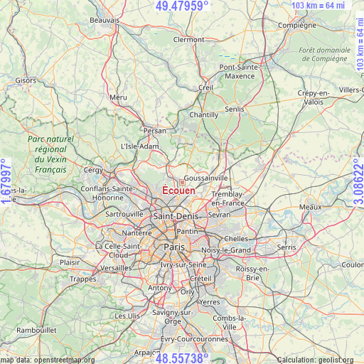
Écouen GPS coordinates[2]
49° 1' 14.232" North, 2° 22' 59.124" East
| Map corner | latitude | longitude |
|---|---|---|
| Upper-left | 49.47959°, | 1.67997° |
| Center: | 49.02062°, | 2.38309° |
| Lower-right: | 48.55738°, | 3.08622° |
| Map W x H: | 102.5×102.5 km | = 63.7×63.7mi |
| max Lat: | 51.07786° ⇑19.8% North |
| Écouen: | 49.02062° |
| min Lat: | ⇓80.2% South 41.3874° |
| min Long | Écouen | max Long |
| -5.08615° | 2.38309° | 9.52242° |
| W 48.6%⇐ | ⇒51.4% E |
Elevation
Elevation of Écouen is 107 m = 351 ft, and this is 86.7 m = 284 ft below average elevation for this country.
| Max E: |
2333 m = 7654 ft | 58.3% |
| Avg. | 193.7 m = 635 ft | |
| Écouen | 107 m = 351 ft | |
Min E: |
-1 m = -3 ft | 41.7% |
See also: France elevation on elevation.city.
Geographical zone
Écouen is located in North temperate zone (between Tropic of Cancer and the Arctic Circle). Distance of this North polar circle is 1950.6 km =1212 mi to North.| Distance of | km | miles | from Écouen |
|---|---|---|---|
| North Pole | 4556.5 | 2831.3 | to North |
| Arctic Circle | 1950.6 | 1212 | to North |
| Tropic Cancer | 2844.7 | 1767.6 | to South |
| Equator | 5450.6 | 3386.8 | to South |


Nearby cities:
15 places around Écouen: (largest is in red/bold)
• Andilly
6 km =3.7 mi,  257°
257°
• Arnouville
4.8 km =3 mi,  149°
149°
• Attainville
5 km =3.1 mi,  326°
326°
• Domont
4.2 km =2.6 mi,  280°
280°
• Garges-lès-Gonesse
6 km =3.7 mi,  169°
169°
• Groslay
4.7 km =2.9 mi,  213°
213°
• Le Mesnil-Aubry
3.7 km =2.3 mi,  18°
18°
• Moisselles
4.7 km =2.9 mi,  313°
313°
• Montmagny
5.9 km =3.7 mi, 206°
• Montmorency
4.6 km =2.9 mi,  218°
218°
• Piscop
2.9 km =1.8 mi,  251°
251°
• Saint-Brice-sous-Forêt
3 km =1.9 mi,  225°
225°
• Sarcelles
2.6 km =1.6 mi,  187°
187°
• Villiers-le-Bel
1.7 km =1.1 mi,  140°
140°
• Ézanville
1.4 km =0.9 mi, 306°
Sources, notices
• [Note1] Compared only with cities in France existing in our database
• [Src1] Map data: © OpenStreetMap contributors (CC-BY-SA)
• [Src2] Other city data from geonames.org with taken over terms of usage.
• [Src3] Geographical zone / Annual Mean Temperature by Robert A. Rohde @ Wikipedia
