Montierchaume geodata
Montierchaume (Centre) is a populated place; located in France in Europe/Paris (GMT+2) time zone. With population of 1,757 people, there are 5389 cities with bigger population in this country. Compared to other cities in France, 56.5% of cities are located further ↑North; 59.7% of cities are located further →East and 56.8% of cities have lower elevation than Montierchaume. Note1
Administrative division(s):
- Level 1: Centre
- Level 2: Département de l'Indre
- Level 3: Arrondissement de Châteauroux
- Level 4: Montierchaume


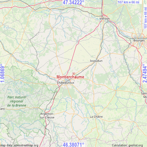
Montierchaume GPS coordinates[2]
46° 51' 49.032" North, 1° 46' 18.516" East
| Map corner | latitude | longitude |
|---|---|---|
| Upper-left | 47.34222°, | 1.06869° |
| Center: | 46.86362°, | 1.77181° |
| Lower-right: | 46.38071°, | 2.47494° |
| Map W x H: | 106.9×106.9 km | = 66.4×66.4mi |
| max Lat: | 51.07786° ⇑56.5% North |
| Montierchaume: | 46.86362° |
| min Lat: | ⇓43.5% South 41.3874° |
| min Long | Montierchaume | max Long |
| -5.08615° | 1.77181° | 9.52242° |
| W 40.3%⇐ | ⇒59.7% E |
Elevation
Elevation of Montierchaume is 157 m = 515 ft, and this is 36.7 m = 120 ft below average elevation for this country.
| Max E: |
2333 m = 7654 ft | 43.2% |
| Avg. | 193.7 m = 635 ft | |
| Montierchaume | 157 m = 515 ft | |
Min E: |
-1 m = -3 ft | 56.8% |
See also: France elevation on elevation.city.
Geographical zone
Montierchaume is located in North temperate zone (between Tropic of Cancer and the Arctic Circle). Distance of this North polar circle is 2190.4 km =1361.1 mi to North.| Distance of | km | miles | from Montierchaume |
|---|---|---|---|
| North Pole | 4796.3 | 2980.3 | to North |
| Arctic Circle | 2190.4 | 1361.1 | to North |
| Tropic Cancer | 2604.8 | 1618.5 | to South |
| Equator | 5210.7 | 3237.8 | to South |


Nearby cities:
15 places around Montierchaume: (largest is in red/bold)
• Ambrault
16.8 km =10.4 mi,  121°
121°
• Ardentes
14.3 km =8.9 mi,  160°
160°
• Châteauroux
8.2 km =5.1 mi,  226°
226°
• Coings
5 km =3.1 mi,  300°
300°
• Diors
5.9 km =3.7 mi,  133°
133°
• Déols
6.4 km =4 mi, 233°
• Le Poinçonnet
11.8 km =7.3 mi,  200°
200°
• Levroux
17.6 km =10.9 mi,  316°
316°
• Mâron
9.3 km =5.8 mi, 131°
• Neuvy-Pailloux
7.2 km =4.5 mi,  70°
70°
• Niherne
16.3 km =10.1 mi,  255°
255°
• Saint-Maur
11.9 km =7.4 mi,  237°
237°
• Villedieu-sur-Indre
17.8 km =11.1 mi, 263°
• Vineuil
11.1 km =6.9 mi,  291°
291°
• Étrechet
9.4 km =5.8 mi,  174°
174°
Sources, notices
• [Note1] Compared only with cities in France existing in our database
• [Src1] Map data: © OpenStreetMap contributors (CC-BY-SA)
• [Src2] Other city data from geonames.org with taken over terms of usage.
• [Src3] Geographical zone / Annual Mean Temperature by Robert A. Rohde @ Wikipedia
