Déols geodata
Déols (Centre) is a populated place; located in France in Europe/Paris (GMT+2) time zone. With population of 8,635 people, there are 1115 cities with bigger population in this country. Compared to other cities in France, 56.9% of cities are located further ↑North; 60.4% of cities are located further →East and 54.7% of cities have lower elevation than Déols. Note1
Administrative division(s):
- Level 1: Centre
- Level 2: Département de l'Indre
- Level 3: Arrondissement de Châteauroux
- Level 4: Déols


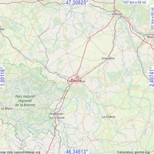
Déols GPS coordinates[2]
46° 49' 45.624" North, 1° 42' 15.408" East
| Map corner | latitude | longitude |
|---|---|---|
| Upper-left | 47.30825°, | 1.00116° |
| Center: | 46.82934°, | 1.70428° |
| Lower-right: | 46.34613°, | 2.40741° |
| Map W x H: | 107×107 km | = 66.5×66.5mi |
| max Lat: | 51.07786° ⇑56.9% North |
| Déols: | 46.82934° |
| min Lat: | ⇓43.1% South 41.3874° |
| min Long | Déols | max Long |
| -5.08615° | 1.70428° | 9.52242° |
| W 39.6%⇐ | ⇒60.4% E |
Elevation
Elevation of Déols is 149 m = 489 ft, and this is 44.7 m = 147 ft below average elevation for this country.
| Max E: |
2333 m = 7654 ft | 45.3% |
| Avg. | 193.7 m = 635 ft | |
| Déols | 149 m = 489 ft | |
Min E: |
-1 m = -3 ft | 54.7% |
See also: France elevation on elevation.city.
Geographical zone
Déols is located in North temperate zone (between Tropic of Cancer and the Arctic Circle). Distance of this North polar circle is 2194.2 km =1363.4 mi to North.| Distance of | km | miles | from Déols |
|---|---|---|---|
| North Pole | 4800.1 | 2982.6 | to North |
| Arctic Circle | 2194.2 | 1363.4 | to North |
| Tropic Cancer | 2601 | 1616.2 | to South |
| Equator | 5206.9 | 3235.4 | to South |


Nearby cities:
15 places around Déols: (largest is in red/bold)
• Ardentes
13.9 km =8.6 mi,  134°
134°
• Arthon
15.1 km =9.4 mi,  181°
181°
• Châteauroux
2 km =1.2 mi,  203°
203°
• Coings
6.4 km =4 mi,  7°
7°
• Diors
9.4 km =5.8 mi,  91°
91°
• Le Poinçonnet
7.3 km =4.5 mi,  171°
171°
• Luant
15.5 km =9.6 mi,  226°
226°
• Montierchaume
6.4 km =4 mi,  53°
53°
• Mâron
12.3 km =7.6 mi,  100°
100°
• Neuvy-Pailloux
13.5 km =8.4 mi,  62°
62°
• Niherne
10.7 km =6.6 mi,  269°
269°
• Saint-Maur
5.6 km =3.5 mi,  242°
242°
• Villedieu-sur-Indre
12.7 km =7.9 mi,  278°
278°
• Vineuil
9.5 km =5.9 mi,  326°
326°
• Étrechet
8.2 km =5.1 mi, 132°
Sources, notices
• [Note1] Compared only with cities in France existing in our database
• [Src1] Map data: © OpenStreetMap contributors (CC-BY-SA)
• [Src2] Other city data from geonames.org with taken over terms of usage.
• [Src3] Geographical zone / Annual Mean Temperature by Robert A. Rohde @ Wikipedia
