Neuvy-Pailloux geodata
Neuvy-Pailloux (Centre) is a populated place; located in France in Europe/Paris (GMT+2) time zone. With population of 1,287 people, there are 7091 cities with bigger population in this country. Compared to other cities in France, 56.3% of cities are located further ↑North; 58.7% of cities are located further →East and 55% of cities have lower elevation than Neuvy-Pailloux. Note1
Administrative division(s):
- Level 1: Centre
- Level 2: Département de l'Indre
- Level 3: Arrondissement d'Issoudun
- Level 4: Neuvy-Pailloux


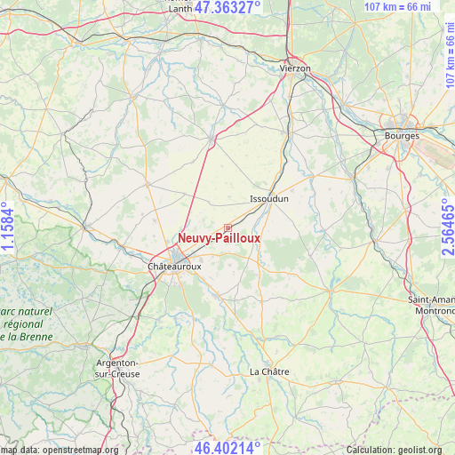
Neuvy-Pailloux GPS coordinates[2]
46° 53' 5.496" North, 1° 51' 41.472" East
| Map corner | latitude | longitude |
|---|---|---|
| Upper-left | 47.36327°, | 1.1584° |
| Center: | 46.88486°, | 1.86152° |
| Lower-right: | 46.40214°, | 2.56465° |
| Map W x H: | 106.9×106.9 km | = 66.4×66.4mi |
| max Lat: | 51.07786° ⇑56.3% North |
| Neuvy-Pailloux: | 46.88486° |
| min Lat: | ⇓43.7% South 41.3874° |
| min Long | Neuvy-Pailloux | max Long |
| -5.08615° | 1.86152° | 9.52242° |
| W 41.3%⇐ | ⇒58.7% E |
Elevation
Elevation of Neuvy-Pailloux is 150 m = 492 ft, and this is 43.7 m = 143 ft below average elevation for this country.
| Max E: |
2333 m = 7654 ft | 45% |
| Avg. | 193.7 m = 635 ft | |
| Neuvy-Pailloux | 150 m = 492 ft | |
Min E: |
-1 m = -3 ft | 55% |
See also: France elevation on elevation.city.
Geographical zone
Neuvy-Pailloux is located in North temperate zone (between Tropic of Cancer and the Arctic Circle). Distance of this North polar circle is 2188.1 km =1359.6 mi to North.| Distance of | km | miles | from Neuvy-Pailloux |
|---|---|---|---|
| North Pole | 4794 | 2978.9 | to North |
| Arctic Circle | 2188.1 | 1359.6 | to North |
| Tropic Cancer | 2607.2 | 1620 | to South |
| Equator | 5213.1 | 3239.3 | to South |


Nearby cities:
15 places around Neuvy-Pailloux: (largest is in red/bold)
• Ambrault
13.5 km =8.4 mi,  146°
146°
• Ardentes
16 km =9.9 mi,  187°
187°
• Châteauroux
15.1 km =9.4 mi,  237°
237°
• Coings
11.1 km =6.9 mi,  270°
270°
• Diors
6.9 km =4.3 mi,  201°
201°
• Déols
13.5 km =8.4 mi, 242°
• Issoudun
12.3 km =7.6 mi,  54°
54°
• Le Poinçonnet
17.3 km =10.7 mi,  219°
219°
• Les Bordes
13.7 km =8.5 mi,  38°
38°
• Montierchaume
7.2 km =4.5 mi,  250°
250°
• Mâron
8.5 km =5.3 mi,  179°
179°
• Pruniers
17.9 km =11.1 mi,  126°
126°
• Sainte-Lizaigne
18.3 km =11.4 mi, 42°
• Vineuil
17.3 km =10.7 mi,  275°
275°
• Étrechet
13.1 km =8.1 mi,  206°
206°
Sources, notices
• [Note1] Compared only with cities in France existing in our database
• [Src1] Map data: © OpenStreetMap contributors (CC-BY-SA)
• [Src2] Other city data from geonames.org with taken over terms of usage.
• [Src3] Geographical zone / Annual Mean Temperature by Robert A. Rohde @ Wikipedia
