Diors geodata
Diors (Centre) is a populated place; located in France in Europe/Paris (GMT+2) time zone. With population of 676 people, there are 12127 cities with bigger population in this country. Compared to other cities in France, 56.9% of cities are located further ↑North; 59.1% of cities are located further →East and 57.1% of cities have lower elevation than Diors. Note1
Administrative division(s):
- Level 1: Centre
- Level 2: Département de l'Indre
- Level 3: Arrondissement de Châteauroux
- Level 4: Diors


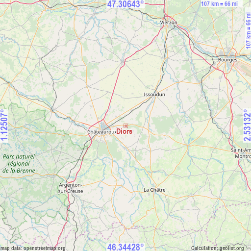
Diors GPS coordinates[2]
46° 49' 39.036" North, 1° 49' 41.484" East
| Map corner | latitude | longitude |
|---|---|---|
| Upper-left | 47.30643°, | 1.12507° |
| Center: | 46.82751°, | 1.82819° |
| Lower-right: | 46.34428°, | 2.53132° |
| Map W x H: | 107×107 km | = 66.5×66.5mi |
| max Lat: | 51.07786° ⇑56.9% North |
| Diors: | 46.82751° |
| min Lat: | ⇓43.1% South 41.3874° |
| min Long | Diors | max Long |
| -5.08615° | 1.82819° | 9.52242° |
| W 40.9%⇐ | ⇒59.1% E |
Elevation
Elevation of Diors is 158 m = 518 ft, and this is 35.7 m = 117 ft below average elevation for this country.
| Max E: |
2333 m = 7654 ft | 42.9% |
| Avg. | 193.7 m = 635 ft | |
| Diors | 158 m = 518 ft | |
Min E: |
-1 m = -3 ft | 57.1% |
See also: France elevation on elevation.city.
Geographical zone
Diors is located in North temperate zone (between Tropic of Cancer and the Arctic Circle). Distance of this North polar circle is 2194.4 km =1363.5 mi to North.| Distance of | km | miles | from Diors |
|---|---|---|---|
| North Pole | 4800.3 | 2982.8 | to North |
| Arctic Circle | 2194.4 | 1363.5 | to North |
| Tropic Cancer | 2600.8 | 1616.1 | to South |
| Equator | 5206.7 | 3235.3 | to South |


Nearby cities:
15 places around Diors: (largest is in red/bold)
• Ambrault
11.1 km =6.9 mi,  116°
116°
• Ardentes
9.5 km =5.9 mi,  177°
177°
• Arthon
17.9 km =11.1 mi,  213°
213°
• Châteauroux
10.4 km =6.5 mi,  260°
260°
• Coings
10.8 km =6.7 mi,  307°
307°
• Déols
9.4 km =5.8 mi,  271°
271°
• Le Poinçonnet
11 km =6.8 mi,  229°
229°
• Montierchaume
5.9 km =3.7 mi, 313°
• Mâron
3.4 km =2.1 mi,  128°
128°
• Neuvy-Pailloux
6.9 km =4.3 mi,  21°
21°
• Pruniers
17.5 km =10.9 mi,  104°
104°
• Saint-Août
14.9 km =9.3 mi,  135°
135°
• Saint-Maur
14.6 km =9.1 mi, 260°
• Vineuil
16.7 km =10.4 mi,  298°
298°
• Étrechet
6.3 km =3.9 mi, 212°
Sources, notices
• [Note1] Compared only with cities in France existing in our database
• [Src1] Map data: © OpenStreetMap contributors (CC-BY-SA)
• [Src2] Other city data from geonames.org with taken over terms of usage.
• [Src3] Geographical zone / Annual Mean Temperature by Robert A. Rohde @ Wikipedia
