Vaujours geodata
Vaujours (Île-de-France) is a populated place; located in France in Europe/Paris (GMT+2) time zone. With population of 5,922 people, there are 1668 cities with bigger population in this country. Compared to other cities in France, 78.2% of cities are located further ↓South; 51.7% of cities are located further ←West and 66.6% of cities have higher elevation than Vaujours. Note1
Administrative division(s):
- Level 1: Île-de-France
- Level 2: Seine-Saint-Denis
- Level 3: Arrondissement du Raincy
- Level 4: Vaujours


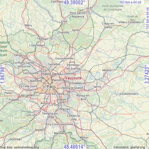
Vaujours GPS coordinates[2]
48° 55' 48.792" North, 2° 34' 15.96" East
| Map corner | latitude | longitude |
|---|---|---|
| Upper-left | 49.39002°, | 1.86798° |
| Center: | 48.93022°, | 2.5711° |
| Lower-right: | 48.46614°, | 3.27423° |
| Map W x H: | 102.7×102.7 km | = 63.8×63.8mi |
| max Lat: | 51.07786° ⇑21.8% North |
| Vaujours: | 48.93022° |
| min Lat: | ⇓78.2% South 41.3874° |
| min Long | Vaujours | max Long |
| -5.08615° | 2.5711° | 9.52242° |
| W 51.7%⇐ | ⇒48.3% E |
Elevation
Elevation of Vaujours is 86 m = 282 ft, and this is 107.7 m = 353 ft below average elevation for this country.
| Max E: |
2333 m = 7654 ft | 66.6% |
| Avg. | 193.7 m = 635 ft | |
| Vaujours | 86 m = 282 ft | |
Min E: |
-1 m = -3 ft | 33.4% |
See also: France elevation on elevation.city.
Geographical zone
Vaujours is located in North temperate zone (between Tropic of Cancer and the Arctic Circle). Distance of this North polar circle is 1960.6 km =1218.3 mi to North.| Distance of | km | miles | from Vaujours |
|---|---|---|---|
| North Pole | 4566.5 | 2837.5 | to North |
| Arctic Circle | 1960.6 | 1218.3 | to North |
| Tropic Cancer | 2834.6 | 1761.3 | to South |
| Equator | 5440.5 | 3380.6 | to South |


Nearby cities:
15 places around Vaujours: (largest is in red/bold)
• Aulnay-sous-Bois
5.7 km =3.5 mi,  278°
278°
• Chelles
5.7 km =3.5 mi,  163°
163°
• Clichy-sous-Bois
2.6 km =1.6 mi,  210°
210°
• Coubron
1.8 km =1.1 mi,  149°
149°
• Courtry
2.7 km =1.7 mi,  117°
117°
• Gagny
5.9 km =3.7 mi, 207°
• Le Pin
4.5 km =2.8 mi,  111°
111°
• Le Raincy
4.9 km =3 mi,  225°
225°
• Les Pavillons-sous-Bois
5.4 km =3.4 mi,  241°
241°
• Livry-Gargan
2.4 km =1.5 mi, 239°
• Montfermeil
3.6 km =2.2 mi,  170°
170°
• Sevran
3.6 km =2.2 mi,  296°
296°
• Tremblay-en-France
2.2 km =1.4 mi,  354°
354°
• Villeparisis
3.4 km =2.1 mi,  67°
67°
• Villepinte
4.5 km =2.8 mi,  321°
321°
Sources, notices
• [Note1] Compared only with cities in France existing in our database
• [Src1] Map data: © OpenStreetMap contributors (CC-BY-SA)
• [Src2] Other city data from geonames.org with taken over terms of usage.
• [Src3] Geographical zone / Annual Mean Temperature by Robert A. Rohde @ Wikipedia
