Mont-Bernanchon geodata
Mont-Bernanchon (Hauts-de-France) is a populated place; located in France in Europe/Paris (GMT+2) time zone. With population of 1,202 people, there are 7519 cities with bigger population in this country. Compared to other cities in France, 98% of cities are located further ↓South; 51.8% of cities are located further ←West and 94.4% of cities have higher elevation than Mont-Bernanchon. Note1
Administrative division(s):
- Level 1: Hauts-de-France
- Level 2: Pas-de-Calais
- Level 3: Arrondissement de Béthune
- Level 4: Mont-Bernanchon


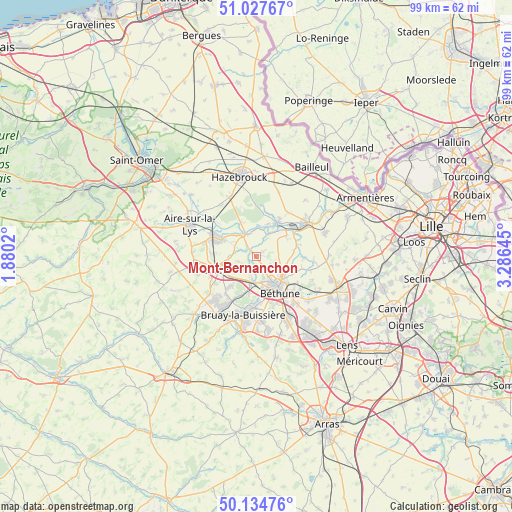
Mont-Bernanchon GPS coordinates[2]
50° 34' 59.988" North, 2° 34' 59.988" East
| Map corner | latitude | longitude |
|---|---|---|
| Upper-left | 51.02767°, | 1.8802° |
| Center: | 50.58333°, | 2.58333° |
| Lower-right: | 50.13476°, | 3.28645° |
| Map W x H: | 99.3×99.3 km | = 61.7×61.7mi |
| max Lat: | 51.07786° ⇑2% North |
| Mont-Bernanchon: | 50.58333° |
| min Lat: | ⇓98% South 41.3874° |
| min Long | Mont-Bernanchon | max Long |
| -5.08615° | 2.58333° | 9.52242° |
| W 51.8%⇐ | ⇒48.2% E |
Elevation
Elevation of Mont-Bernanchon is 19 m = 62 ft, and this is 174.7 m = 573 ft below average elevation for this country.
| Max E: |
2333 m = 7654 ft | 94.4% |
| Avg. | 193.7 m = 635 ft | |
| Mont-Bernanchon | 19 m = 62 ft | |
Min E: |
-1 m = -3 ft | 5.6% |
See also: France elevation on elevation.city.
Geographical zone
Mont-Bernanchon is located in North temperate zone (between Tropic of Cancer and the Arctic Circle). Distance of this North polar circle is 1776.8 km =1104.1 mi to North.| Distance of | km | miles | from Mont-Bernanchon |
|---|---|---|---|
| North Pole | 4382.7 | 2723.3 | to North |
| Arctic Circle | 1776.8 | 1104.1 | to North |
| Tropic Cancer | 3018.4 | 1875.5 | to South |
| Equator | 5624.3 | 3494.8 | to South |


Nearby cities:
15 places around Mont-Bernanchon: (largest is in red/bold)
• Annezin
6.2 km =3.9 mi,  156°
156°
• Busnes
4.6 km =2.9 mi,  276°
276°
• Béthune
7.2 km =4.5 mi,  146°
146°
• Calonne-sur-la-Lys
5 km =3.1 mi,  28°
28°
• Chocques
4.8 km =3 mi,  189°
189°
• Essars
7 km =4.3 mi,  123°
123°
• Fouquereuil
7.3 km =4.5 mi,  170°
170°
• Gonnehem
2.6 km =1.6 mi,  196°
196°
• Haverskerque
7 km =4.3 mi,  335°
335°
• Hinges
3.3 km =2.1 mi, 124°
• Labeuvrière
7.3 km =4.5 mi, 191°
• Locon
6 km =3.7 mi,  103°
103°
• Robecq
2 km =1.2 mi,  314°
314°
• Saint-Venant
5.1 km =3.2 mi,  322°
322°
• Vendin-lès-Béthune
5 km =3.1 mi, 165°
Sources, notices
• [Note1] Compared only with cities in France existing in our database
• [Src1] Map data: © OpenStreetMap contributors (CC-BY-SA)
• [Src2] Other city data from geonames.org with taken over terms of usage.
• [Src3] Geographical zone / Annual Mean Temperature by Robert A. Rohde @ Wikipedia
