Poulx geodata
Poulx (Occitanie) is a populated place; located in France in Europe/Paris (GMT+2) time zone. With population of 3,950 people, there are 2495 cities with bigger population in this country. Compared to other cities in France, 88% of cities are located further ↑North; 71.5% of cities are located further ←West and 60.9% of cities have lower elevation than Poulx. Note1
Administrative division(s):
- Level 1: Occitanie
- Level 2: Gard
- Level 3: Arrondissement de Nîmes
- Level 4: Poulx


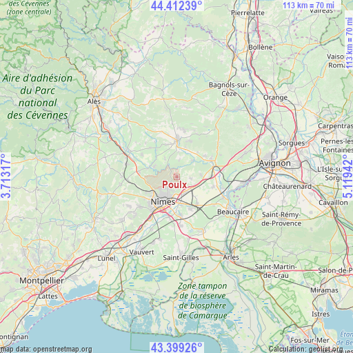
Poulx GPS coordinates[2]
43° 54' 28.728" North, 4° 24' 58.644" East
| Map corner | latitude | longitude |
|---|---|---|
| Upper-left | 44.41239°, | 3.71317° |
| Center: | 43.90798°, | 4.41629° |
| Lower-right: | 43.39926°, | 5.11942° |
| Map W x H: | 112.6×112.6 km | = 70×70mi |
| max Lat: | 51.07786° ⇑88% North |
| Poulx: | 43.90798° |
| min Lat: | ⇓12% South 41.3874° |
| min Long | Poulx | max Long |
| -5.08615° | 4.41629° | 9.52242° |
| W 71.5%⇐ | ⇒28.5% E |
Elevation
Elevation of Poulx is 174 m = 571 ft, and this is 19.7 m = 65 ft below average elevation for this country.
| Max E: |
2333 m = 7654 ft | 39.1% |
| Avg. | 193.7 m = 635 ft | |
| Poulx | 174 m = 571 ft | |
Min E: |
-1 m = -3 ft | 60.9% |
See also: France elevation on elevation.city.
Geographical zone
Poulx is located in North temperate zone (between Tropic of Cancer and the Arctic Circle). Distance of this Northern Tropic circle is 2276.2 km =1414.4 mi to South.| Distance of | km | miles | from Poulx |
|---|---|---|---|
| North Pole | 5125 | 3184.5 | to North |
| Arctic Circle | 2519.1 | 1565.3 | to North |
| Tropic Cancer | 2276.2 | 1414.4 | to South |
| Equator | 4882.1 | 3033.6 | to South |


Nearby cities:
15 places around Poulx: (largest is in red/bold)
• Bezouce
6.6 km =4.1 mi,  115°
115°
• Blauzac
7 km =4.3 mi,  327°
327°
• Cabrières
4.4 km =2.7 mi,  95°
95°
• Collias
7.2 km =4.5 mi,  43°
43°
• Dions
10 km =6.2 mi,  285°
285°
• Lédenon
7.9 km =4.9 mi,  85°
85°
• Marguerittes
5.9 km =3.7 mi,  156°
156°
• Nîmes
9.4 km =5.8 mi,  208°
208°
• Redessan
10.7 km =6.6 mi,  142°
142°
• Rodilhan
9.1 km =5.7 mi,  172°
172°
• Sagriès
7.9 km =4.9 mi,  1°
1°
• Saint-Bonnet-du-Gard
10.5 km =6.5 mi,  79°
79°
• Saint-Gervasy
5.3 km =3.3 mi,  131°
131°
• Saint-Maximin
10 km =6.2 mi,  16°
16°
• Sernhac
10.7 km =6.6 mi, 88°
Sources, notices
• [Note1] Compared only with cities in France existing in our database
• [Src1] Map data: © OpenStreetMap contributors (CC-BY-SA)
• [Src2] Other city data from geonames.org with taken over terms of usage.
• [Src3] Geographical zone / Annual Mean Temperature by Robert A. Rohde @ Wikipedia
