Saint-Maurice-de-Cazevieille geodata
Saint-Maurice-de-Cazevieille (Occitanie) is a populated place; located in France in Europe/Paris (GMT+2) time zone. With population of 526 people, there are 14691 cities with bigger population in this country. Compared to other cities in France, 86.8% of cities are located further ↑North; 70% of cities are located further ←West and 55% of cities have lower elevation than Saint-Maurice-de-Cazevieille. Note1
Administrative division(s):
- Level 1: Occitanie
- Level 2: Gard
- Level 3: Arrondissement d’Alès
- Level 4: Saint-Maurice-de-Cazevieille
Current local time in Saint-Maurice-de-Cazevieille:
11:13 PM, SaturdayDifference from your time zone: hours


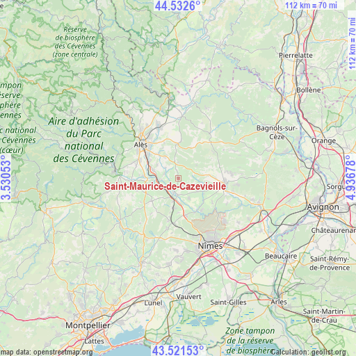
Saint-Maurice-de-Cazevieille GPS coordinates[2]
44° 1' 45.192" North, 4° 14' 1.14" East
| Map corner | latitude | longitude |
|---|---|---|
| Upper-left | 44.5326°, | 3.53053° |
| Center: | 44.02922°, | 4.23365° |
| Lower-right: | 43.52153°, | 4.93678° |
| Map W x H: | 112.4×112.4 km | = 69.8×69.8mi |
| max Lat: | 51.07786° ⇑86.8% North |
| Saint-Maurice-de-Cazevieille: | 44.02922° |
| min Lat: | ⇓13.2% South 41.3874° |
| min Long | Saint-Maurice-d | max Long |
| -5.08615° | 4.23365° | 9.52242° |
| W 70%⇐ | ⇒30% E |
Elevation
Elevation of Saint-Maurice-de-Cazevieille is 150 m = 492 ft, and this is 43.7 m = 143 ft below average elevation for this country.
| Max E: |
2333 m = 7654 ft | 45% |
| Avg. | 193.7 m = 635 ft | |
| Saint-Maurice-de-Cazevieille | 150 m = 492 ft | |
Min E: |
-1 m = -3 ft | 55% |
See also: France elevation on elevation.city.
Geographical zone
Saint-Maurice-de-Cazevieille is located in North temperate zone (between Tropic of Cancer and the Arctic Circle). Distance of this Northern Tropic circle is 2289.7 km =1422.8 mi to South.| Distance of | km | miles | from Saint-Maurice-de-Cazevieille |
|---|---|---|---|
| North Pole | 5111.5 | 3176.1 | to North |
| Arctic Circle | 2505.6 | 1556.9 | to North |
| Tropic Cancer | 2289.7 | 1422.8 | to South |
| Equator | 4895.6 | 3042 | to South |


Nearby cities:
15 places around Saint-Maurice-de-Cazevieille: (largest is in red/bold)
• Boucoiran-et-Nozières
5.4 km =3.4 mi,  225°
225°
• Brignon
4.8 km =3 mi,  199°
199°
• Cruviers-Lascours
3.8 km =2.4 mi,  219°
219°
• Deaux
7.9 km =4.9 mi,  301°
301°
• Domessargues
8 km =5 mi, 221°
• Garrigues-Sainte-Eulalie
8.4 km =5.2 mi,  127°
127°
• Mons
10.7 km =6.6 mi,  333°
333°
• Moussac
5.4 km =3.4 mi,  186°
186°
• Méjannes-lès-Alès
9.9 km =6.2 mi,  321°
321°
• Ners
5.8 km =3.6 mi,  267°
267°
• Saint-Chaptes
7.3 km =4.5 mi,  150°
150°
• Saint-Geniès-de-Malgoirès
8.9 km =5.5 mi, 188°
• Saint-Hilaire-de-Brethmas
10.4 km =6.5 mi, 302°
• Sauzet
7.8 km =4.8 mi, 194°
• Vézénobres
8 km =5 mi,  287°
287°
Sources, notices
• [Note1] Compared only with cities in France existing in our database
• [Src1] Map data: © OpenStreetMap contributors (CC-BY-SA)
• [Src2] Other city data from geonames.org with taken over terms of usage.
• [Src3] Geographical zone / Annual Mean Temperature by Robert A. Rohde @ Wikipedia
