Montaigut-sur-Save geodata
Montaigut-sur-Save (Occitanie) is a populated place; located in France in Europe/Paris (GMT+2) time zone. With population of 1,360 people, there are 6763 cities with bigger population in this country. Compared to other cities in France, 90.6% of cities are located further ↑North; 66.4% of cities are located further →East and 52.5% of cities have lower elevation than Montaigut-sur-Save. Note1
Administrative division(s):
- Level 1: Occitanie
- Level 2: Haute-Garonne
- Level 3: Arrondissement de Toulouse
- Level 4: Montaigut-sur-Save


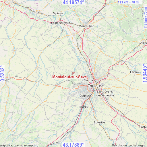
Montaigut-sur-Save GPS coordinates[2]
43° 41' 22.092" North, 1° 13' 52.788" East
| Map corner | latitude | longitude |
|---|---|---|
| Upper-left | 44.19574°, | 0.5282° |
| Center: | 43.68947°, | 1.23133° |
| Lower-right: | 43.17889°, | 1.93445° |
| Map W x H: | 113.1×113.1 km | = 70.3×70.3mi |
| max Lat: | 51.07786° ⇑90.6% North |
| Montaigut-sur-Save: | 43.68947° |
| min Lat: | ⇓9.4% South 41.3874° |
| min Long | Montaigut-sur-S | max Long |
| -5.08615° | 1.23133° | 9.52242° |
| W 33.6%⇐ | ⇒66.4% E |
Elevation
Elevation of Montaigut-sur-Save is 141 m = 463 ft, and this is 52.7 m = 173 ft below average elevation for this country.
| Max E: |
2333 m = 7654 ft | 47.5% |
| Avg. | 193.7 m = 635 ft | |
| Montaigut-sur-Save | 141 m = 463 ft | |
Min E: |
-1 m = -3 ft | 52.5% |
See also: France elevation on elevation.city.
Geographical zone
Montaigut-sur-Save is located in North temperate zone (between Tropic of Cancer and the Arctic Circle). Distance of this Northern Tropic circle is 2251.9 km =1399.3 mi to South.| Distance of | km | miles | from Montaigut-sur-Save |
|---|---|---|---|
| North Pole | 5149.2 | 3199.6 | to North |
| Arctic Circle | 2543.4 | 1580.4 | to North |
| Tropic Cancer | 2251.9 | 1399.3 | to South |
| Equator | 4857.8 | 3018.5 | to South |


Nearby cities:
15 places around Montaigut-sur-Save: (largest is in red/bold)
• Aussonne
7.1 km =4.4 mi,  97°
97°
• Brax
8 km =5 mi,  175°
175°
• Cornebarrieu
8.7 km =5.4 mi,  121°
121°
• Daux
3.1 km =1.9 mi,  78°
78°
• Grenade
9.5 km =5.9 mi,  25°
25°
• Lasserre
7.6 km =4.7 mi,  222°
222°
• Launac
7.2 km =4.5 mi,  326°
326°
• Le Castéra
7.5 km =4.7 mi,  256°
256°
• Léguevin
9.9 km =6.2 mi, 179°
• Lévignac
3.6 km =2.2 mi, 224°
• Merville
6.5 km =4 mi,  54°
54°
• Mondonville
4.8 km =3 mi,  112°
112°
• Pibrac
8.8 km =5.5 mi,  150°
150°
• Seilh
10 km =6.2 mi,  86°
86°
• Thil
6.4 km =4 mi,  293°
293°
Sources, notices
• [Note1] Compared only with cities in France existing in our database
• [Src1] Map data: © OpenStreetMap contributors (CC-BY-SA)
• [Src2] Other city data from geonames.org with taken over terms of usage.
• [Src3] Geographical zone / Annual Mean Temperature by Robert A. Rohde @ Wikipedia
