Pibrac geodata
Pibrac (Occitanie) is a populated place; located in France in Europe/Paris (GMT+2) time zone. With population of 8,413 people, there are 1155 cities with bigger population in this country. Compared to other cities in France, 91.6% of cities are located further ↑North; 65.8% of cities are located further →East and 58.4% of cities have lower elevation than Pibrac. Note1
Administrative division(s):
- Level 1: Occitanie
- Level 2: Haute-Garonne
- Level 3: Arrondissement de Toulouse
- Level 4: Pibrac


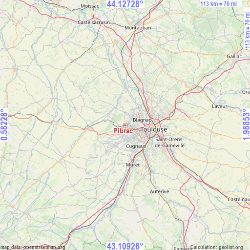
Pibrac GPS coordinates[2]
43° 37' 13.512" North, 1° 17' 7.44" East
| Map corner | latitude | longitude |
|---|---|---|
| Upper-left | 44.12728°, | 0.58228° |
| Center: | 43.62042°, | 1.2854° |
| Lower-right: | 43.10926°, | 1.98853° |
| Map W x H: | 113.2×113.2 km | = 70.3×70.3mi |
| max Lat: | 51.07786° ⇑91.6% North |
| Pibrac: | 43.62042° |
| min Lat: | ⇓8.4% South 41.3874° |
| min Long | Pibrac | max Long |
| -5.08615° | 1.2854° | 9.52242° |
| W 34.2%⇐ | ⇒65.8% E |
Elevation
Elevation of Pibrac is 163 m = 535 ft, and this is 30.7 m = 101 ft below average elevation for this country.
| Max E: |
2333 m = 7654 ft | 41.6% |
| Avg. | 193.7 m = 635 ft | |
| Pibrac | 163 m = 535 ft | |
Min E: |
-1 m = -3 ft | 58.4% |
See also: France elevation on elevation.city.
Geographical zone
Pibrac is located in North temperate zone (between Tropic of Cancer and the Arctic Circle). Distance of this Northern Tropic circle is 2244.2 km =1394.5 mi to South.| Distance of | km | miles | from Pibrac |
|---|---|---|---|
| North Pole | 5156.9 | 3204.3 | to North |
| Arctic Circle | 2551 | 1585.1 | to North |
| Tropic Cancer | 2244.2 | 1394.5 | to South |
| Equator | 4850.1 | 3013.7 | to South |


Nearby cities:
15 places around Pibrac: (largest is in red/bold)
• Aussonne
7.3 km =4.5 mi,  21°
21°
• Beauzelle
8.9 km =5.5 mi,  54°
54°
• Blagnac
8.8 km =5.5 mi,  81°
81°
• Brax
3.7 km =2.3 mi,  265°
265°
• Colomiers
4.1 km =2.5 mi,  105°
105°
• Cornebarrieu
4.4 km =2.7 mi,  44°
44°
• Daux
8.4 km =5.2 mi,  350°
350°
• La Salvetat-Saint-Gilles
5 km =3.1 mi,  192°
192°
• Lasserre
9.7 km =6 mi,  282°
282°
• Léguevin
4.8 km =3 mi,  242°
242°
• Lévignac
8.6 km =5.3 mi,  306°
306°
• Mondonville
5.8 km =3.6 mi,  0°
0°
• Montaigut-sur-Save
8.8 km =5.5 mi,  330°
330°
• Plaisance-du-Touch
6.2 km =3.9 mi,  170°
170°
• Tournefeuille
4.5 km =2.8 mi,  142°
142°
Sources, notices
• [Note1] Compared only with cities in France existing in our database
• [Src1] Map data: © OpenStreetMap contributors (CC-BY-SA)
• [Src2] Other city data from geonames.org with taken over terms of usage.
• [Src3] Geographical zone / Annual Mean Temperature by Robert A. Rohde @ Wikipedia
