Lévignac geodata
Lévignac (Occitanie) is a populated place; located in France in Europe/Paris (GMT+2) time zone. With population of 1,827 people, there are 5188 cities with bigger population in this country. Compared to other cities in France, 91% of cities are located further ↑North; 66.8% of cities are located further →East and 59.6% of cities have lower elevation than Lévignac. Note1
Administrative division(s):
- Level 1: Occitanie
- Level 2: Haute-Garonne
- Level 3: Arrondissement de Toulouse
- Level 4: Lévignac


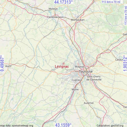
Lévignac GPS coordinates[2]
43° 40' 0.012" North, 1° 12' 0" East
| Map corner | latitude | longitude |
|---|---|---|
| Upper-left | 44.17313°, | 0.49687° |
| Center: | 43.66667°, | 1.2° |
| Lower-right: | 43.1559°, | 1.90312° |
| Map W x H: | 113.1×113.1 km | = 70.3×70.3mi |
| max Lat: | 51.07786° ⇑91% North |
| Lévignac: | 43.66667° |
| min Lat: | ⇓9% South 41.3874° |
| min Long | Lévignac | max Long |
| -5.08615° | 1.2° | 9.52242° |
| W 33.2%⇐ | ⇒66.8% E |
Elevation
Elevation of Lévignac is 168 m = 551 ft, and this is 25.7 m = 84 ft below average elevation for this country.
| Max E: |
2333 m = 7654 ft | 40.4% |
| Avg. | 193.7 m = 635 ft | |
| Lévignac | 168 m = 551 ft | |
Min E: |
-1 m = -3 ft | 59.6% |
See also: France elevation on elevation.city.
Geographical zone
Lévignac is located in North temperate zone (between Tropic of Cancer and the Arctic Circle). Distance of this Northern Tropic circle is 2249.4 km =1397.7 mi to South.| Distance of | km | miles | from Lévignac |
|---|---|---|---|
| North Pole | 5151.8 | 3201.2 | to North |
| Arctic Circle | 2545.9 | 1581.9 | to North |
| Tropic Cancer | 2249.4 | 1397.7 | to South |
| Equator | 4855.3 | 3016.9 | to South |


Nearby cities:
15 places around Lévignac: (largest is in red/bold)
• Aussonne
9.7 km =6 mi,  80°
80°
• Brax
6.3 km =3.9 mi,  149°
149°
• Cornebarrieu
10.2 km =6.3 mi,  101°
101°
• Daux
6.4 km =4 mi,  60°
60°
• Lasserre
4 km =2.5 mi,  220°
220°
• Launac
8.7 km =5.4 mi,  350°
350°
• Le Castéra
4.8 km =3 mi,  279°
279°
• Léguevin
7.8 km =4.8 mi,  160°
160°
• Merville
10 km =6.2 mi,  50°
50°
• Mondonville
6.9 km =4.3 mi, 84°
• Montaigut-sur-Save
3.6 km =2.2 mi,  44°
44°
• Pibrac
8.6 km =5.3 mi,  126°
126°
• Pujaudran
9.5 km =5.9 mi,  205°
205°
• Ségoufielle
6.8 km =4.2 mi,  234°
234°
• Thil
6.1 km =3.8 mi,  326°
326°
Sources, notices
• [Note1] Compared only with cities in France existing in our database
• [Src1] Map data: © OpenStreetMap contributors (CC-BY-SA)
• [Src2] Other city data from geonames.org with taken over terms of usage.
• [Src3] Geographical zone / Annual Mean Temperature by Robert A. Rohde @ Wikipedia
