Moncrabeau geodata
Moncrabeau (Nouvelle-Aquitaine) is a populated place; located in France in Europe/Paris (GMT+2) time zone. With population of 814 people, there are 10439 cities with bigger population in this country. Compared to other cities in France, 86.8% of cities are located further ↑North; 74.6% of cities are located further →East and 60.4% of cities have higher elevation than Moncrabeau. Note1
Administrative division(s):
- Level 1: Nouvelle-Aquitaine
- Level 2: Département du Lot-et-Garonne
- Level 3: Arrondissement de Nérac
- Level 4: Moncrabeau


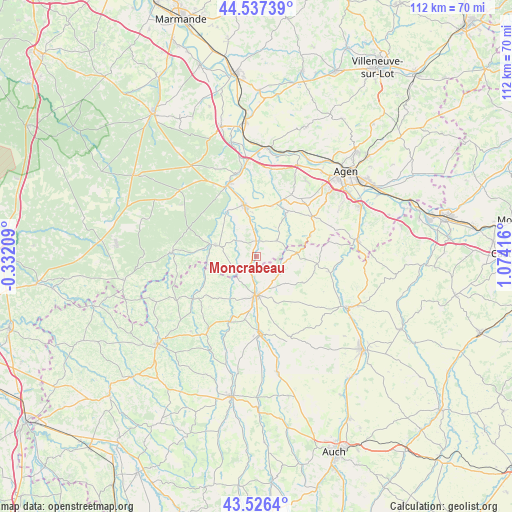
Moncrabeau GPS coordinates[2]
44° 2' 2.58" North, 0° 22' 15.744" East
| Map corner | latitude | longitude |
|---|---|---|
| Upper-left | 44.53739°, | -0.33209° |
| Center: | 44.03405°, | 0.37104° |
| Lower-right: | 43.5264°, | 1.07416° |
| Map W x H: | 112.4×112.4 km | = 69.8×69.8mi |
| max Lat: | 51.07786° ⇑86.8% North |
| Moncrabeau: | 44.03405° |
| min Lat: | ⇓13.2% South 41.3874° |
| min Long | Moncrabeau | max Long |
| -5.08615° | 0.37104° | 9.52242° |
| W 25.4%⇐ | ⇒74.6% E |
Elevation
Elevation of Moncrabeau is 101 m = 331 ft, and this is 92.7 m = 304 ft below average elevation for this country.
| Max E: |
2333 m = 7654 ft | 60.4% |
| Avg. | 193.7 m = 635 ft | |
| Moncrabeau | 101 m = 331 ft | |
Min E: |
-1 m = -3 ft | 39.6% |
See also: France elevation on elevation.city.
Geographical zone
Moncrabeau is located in North temperate zone (between Tropic of Cancer and the Arctic Circle). Distance of this Northern Tropic circle is 2290.2 km =1423.1 mi to South.| Distance of | km | miles | from Moncrabeau |
|---|---|---|---|
| North Pole | 5110.9 | 3175.8 | to North |
| Arctic Circle | 2505 | 1556.5 | to North |
| Tropic Cancer | 2290.2 | 1423.1 | to South |
| Equator | 4896.1 | 3042.3 | to South |


Nearby cities:
15 places around Moncrabeau: (largest is in red/bold)
• Barbaste
16.5 km =10.3 mi,  335°
335°
• Caussens
10.9 km =6.8 mi,  157°
157°
• Condom
8.4 km =5.2 mi,  179°
179°
• Francescas
5.7 km =3.5 mi,  53°
53°
• La Romieu
11.8 km =7.3 mi,  119°
119°
• Laplume
15.4 km =9.6 mi,  55°
55°
• Lavardac
17 km =10.6 mi, 340°
• Lisse
13.7 km =8.5 mi,  306°
306°
• Montagnac-sur-Auvignon
15.8 km =9.8 mi,  26°
26°
• Montréal
16.3 km =10.1 mi,  235°
235°
• Mézin
9.3 km =5.8 mi,  285°
285°
• Nérac
11.6 km =7.2 mi,  347°
347°
• Sos
18.3 km =11.4 mi,  272°
272°
• Valence-sur-Baïse
16.8 km =10.4 mi, 177°
• Vianne
18.5 km =11.5 mi, 347°
Sources, notices
• [Note1] Compared only with cities in France existing in our database
• [Src1] Map data: © OpenStreetMap contributors (CC-BY-SA)
• [Src2] Other city data from geonames.org with taken over terms of usage.
• [Src3] Geographical zone / Annual Mean Temperature by Robert A. Rohde @ Wikipedia
