Francescas geodata
Francescas (Nouvelle-Aquitaine) is a populated place; located in France in Europe/Paris (GMT+2) time zone. With population of 736 people, there are 11334 cities with bigger population in this country. Compared to other cities in France, 86.6% of cities are located further ↑North; 74% of cities are located further →East and 52.3% of cities have higher elevation than Francescas. Note1
Administrative division(s):
- Level 1: Nouvelle-Aquitaine
- Level 2: Département du Lot-et-Garonne
- Level 3: Arrondissement de Nérac
- Level 4: Francescas


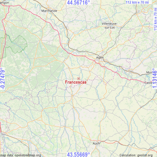
Francescas GPS coordinates[2]
44° 3' 50.688" North, 0° 25' 42.024" East
| Map corner | latitude | longitude |
|---|---|---|
| Upper-left | 44.56716°, | -0.27479° |
| Center: | 44.06408°, | 0.42834° |
| Lower-right: | 43.55669°, | 1.13146° |
| Map W x H: | 112.4×112.4 km | = 69.8×69.8mi |
| max Lat: | 51.07786° ⇑86.6% North |
| Francescas: | 44.06408° |
| min Lat: | ⇓13.4% South 41.3874° |
| min Long | Francescas | max Long |
| -5.08615° | 0.42834° | 9.52242° |
| W 26%⇐ | ⇒74% E |
Elevation
Elevation of Francescas is 124 m = 407 ft, and this is 69.7 m = 229 ft below average elevation for this country.
| Max E: |
2333 m = 7654 ft | 52.3% |
| Avg. | 193.7 m = 635 ft | |
| Francescas | 124 m = 407 ft | |
Min E: |
-1 m = -3 ft | 47.7% |
See also: France elevation on elevation.city.
Geographical zone
Francescas is located in North temperate zone (between Tropic of Cancer and the Arctic Circle). Distance of this Northern Tropic circle is 2293.5 km =1425.1 mi to South.| Distance of | km | miles | from Francescas |
|---|---|---|---|
| North Pole | 5107.6 | 3173.7 | to North |
| Arctic Circle | 2501.7 | 1554.5 | to North |
| Tropic Cancer | 2293.5 | 1425.1 | to South |
| Equator | 4899.5 | 3044.4 | to South |


Nearby cities:
15 places around Francescas: (largest is in red/bold)
• Aubiac
13.6 km =8.5 mi,  50°
50°
• Bruch
15.7 km =9.8 mi,  355°
355°
• Caussens
13.4 km =8.3 mi,  181°
181°
• Condom
12.6 km =7.8 mi,  200°
200°
• Estillac
15 km =9.3 mi, 46°
• La Romieu
10.8 km =6.7 mi,  147°
147°
• Laplume
9.8 km =6.1 mi,  56°
56°
• Lisse
16.3 km =10.1 mi,  287°
287°
• Moncrabeau
5.7 km =3.5 mi,  233°
233°
• Montagnac-sur-Auvignon
11.1 km =6.9 mi,  13°
13°
• Montesquieu
15.3 km =9.5 mi,  3°
3°
• Mézin
13.6 km =8.5 mi,  266°
266°
• Nérac
10.7 km =6.6 mi,  318°
318°
• Roquefort
16.3 km =10.1 mi,  40°
40°
• Sainte-Colombe-en-Bruilhois
14.5 km =9 mi,  28°
28°
Sources, notices
• [Note1] Compared only with cities in France existing in our database
• [Src1] Map data: © OpenStreetMap contributors (CC-BY-SA)
• [Src2] Other city data from geonames.org with taken over terms of usage.
• [Src3] Geographical zone / Annual Mean Temperature by Robert A. Rohde @ Wikipedia
