Montréal geodata
Montréal (Occitanie) is a populated place; located in France in Europe/Paris (GMT+2) time zone. With population of 1,302 people, there are 7017 cities with bigger population in this country. Compared to other cities in France, 87.5% of cities are located further ↑North; 76.2% of cities are located further →East and 51.7% of cities have higher elevation than Montréal. Note1
Administrative division(s):
- Level 1: Occitanie
- Level 2: Gers
- Level 3: Arrondissement de Condom
- Level 4: Montréal


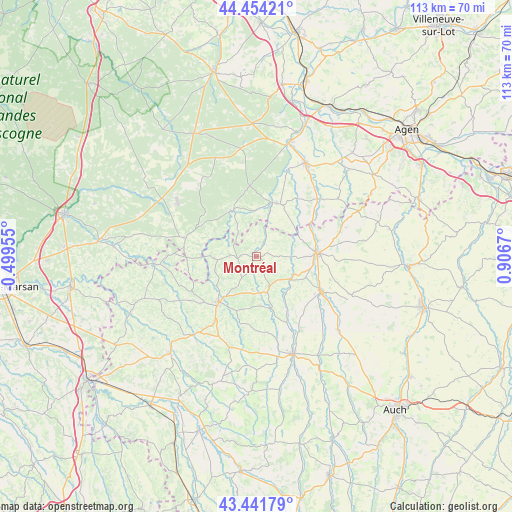
Montréal GPS coordinates[2]
43° 57' 0.576" North, 0° 12' 12.888" East
| Map corner | latitude | longitude |
|---|---|---|
| Upper-left | 44.45421°, | -0.49955° |
| Center: | 43.95016°, | 0.20358° |
| Lower-right: | 43.44179°, | 0.9067° |
| Map W x H: | 112.6×112.6 km | = 70×70mi |
| max Lat: | 51.07786° ⇑87.5% North |
| Montréal: | 43.95016° |
| min Lat: | ⇓12.5% South 41.3874° |
| min Long | Montréal | max Long |
| -5.08615° | 0.20358° | 9.52242° |
| W 23.8%⇐ | ⇒76.2% E |
Elevation
Elevation of Montréal is 126 m = 413 ft, and this is 67.7 m = 222 ft below average elevation for this country.
| Max E: |
2333 m = 7654 ft | 51.7% |
| Avg. | 193.7 m = 635 ft | |
| Montréal | 126 m = 413 ft | |
Min E: |
-1 m = -3 ft | 48.3% |
See also: France elevation on elevation.city.
Geographical zone
Montréal is located in North temperate zone (between Tropic of Cancer and the Arctic Circle). Distance of this Northern Tropic circle is 2280.9 km =1417.3 mi to South.| Distance of | km | miles | from Montréal |
|---|---|---|---|
| North Pole | 5120.3 | 3181.6 | to North |
| Arctic Circle | 2514.4 | 1562.4 | to North |
| Tropic Cancer | 2280.9 | 1417.3 | to South |
| Equator | 4886.8 | 3036.5 | to South |


Nearby cities:
15 places around Montréal: (largest is in red/bold)
• Caussens
17.7 km =11 mi,  92°
92°
• Cazaubon
21.8 km =13.5 mi,  265°
265°
• Condom
13.5 km =8.4 mi, 86°
• Eauze
12.9 km =8 mi,  219°
219°
• Gabarret
16.1 km =10 mi,  285°
285°
• Gondrin
7.8 km =4.8 mi,  159°
159°
• Lannepax
16.8 km =10.4 mi,  173°
173°
• Lisse
17.6 km =10.9 mi,  7°
7°
• Manciet
21.1 km =13.1 mi, 217°
• Moncrabeau
16.3 km =10.1 mi,  55°
55°
• Mézin
12.6 km =7.8 mi,  20°
20°
• Parleboscq
16.4 km =10.2 mi,  263°
263°
• Sos
11.3 km =7 mi,  334°
334°
• Valence-sur-Baïse
16.1 km =10 mi,  117°
117°
• Vic-Fezensac
21.7 km =13.5 mi, 156°
Sources, notices
• [Note1] Compared only with cities in France existing in our database
• [Src1] Map data: © OpenStreetMap contributors (CC-BY-SA)
• [Src2] Other city data from geonames.org with taken over terms of usage.
• [Src3] Geographical zone / Annual Mean Temperature by Robert A. Rohde @ Wikipedia
