Condom geodata
Condom (Occitanie) is a seat of a third-order administrative division; located in France in Europe/Paris (GMT+2) time zone. With population of 7,732 people, there are 1253 cities with bigger population in this country. Compared to other cities in France, 87.5% of cities are located further ↑North; 74.6% of cities are located further →East and 64.4% of cities have higher elevation than Condom. Note1
Administrative division(s):
- Level 1: Occitanie
- Level 2: Gers
- Level 3: Arrondissement de Condom
- Level 4: Condom


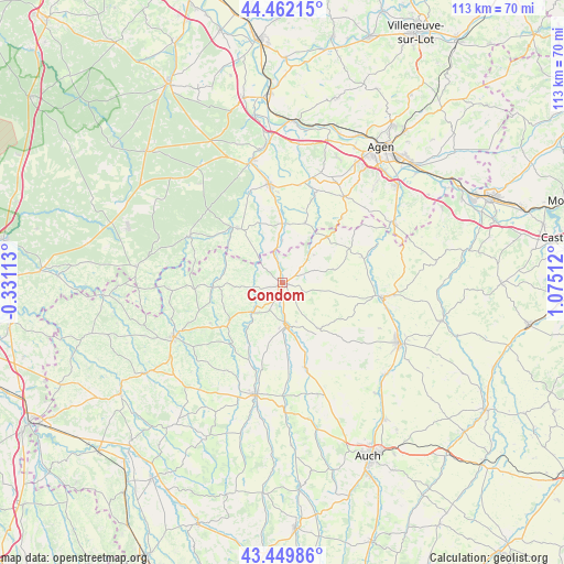
Condom GPS coordinates[2]
43° 57' 29.376" North, 0° 22' 19.164" East
| Map corner | latitude | longitude |
|---|---|---|
| Upper-left | 44.46215°, | -0.33113° |
| Center: | 43.95816°, | 0.37199° |
| Lower-right: | 43.44986°, | 1.07512° |
| Map W x H: | 112.6×112.6 km | = 70×70mi |
| max Lat: | 51.07786° ⇑87.5% North |
| Condom: | 43.95816° |
| min Lat: | ⇓12.5% South 41.3874° |
| min Long | Condom | max Long |
| -5.08615° | 0.37199° | 9.52242° |
| W 25.4%⇐ | ⇒74.6% E |
Elevation
Elevation of Condom is 91 m = 299 ft, and this is 102.7 m = 337 ft below average elevation for this country.
| Max E: |
2333 m = 7654 ft | 64.4% |
| Avg. | 193.7 m = 635 ft | |
| Condom | 91 m = 299 ft | |
Min E: |
-1 m = -3 ft | 35.6% |
See also: France elevation on elevation.city.
Geographical zone
Condom is located in North temperate zone (between Tropic of Cancer and the Arctic Circle). Distance of this Northern Tropic circle is 2281.8 km =1417.8 mi to South.| Distance of | km | miles | from Condom |
|---|---|---|---|
| North Pole | 5119.4 | 3181 | to North |
| Arctic Circle | 2513.5 | 1561.8 | to North |
| Tropic Cancer | 2281.8 | 1417.8 | to South |
| Equator | 4887.7 | 3037.1 | to South |


Nearby cities:
15 places around Condom: (largest is in red/bold)
• Castéra-Verduzan
17.6 km =10.9 mi,  164°
164°
• Caussens
4.5 km =2.8 mi,  111°
111°
• Francescas
12.6 km =7.8 mi,  20°
20°
• Gondrin
13.5 km =8.4 mi,  232°
232°
• La Romieu
10.6 km =6.6 mi,  75°
75°
• Lannepax
21 km =13 mi,  213°
213°
• Lectoure
20.1 km =12.5 mi,  97°
97°
• Lisse
19.9 km =12.4 mi,  326°
326°
• Moncrabeau
8.4 km =5.2 mi,  359°
359°
• Montréal
13.5 km =8.4 mi,  266°
266°
• Mézin
14.2 km =8.8 mi,  320°
320°
• Nérac
20 km =12.4 mi,  352°
352°
• Saint-Puy
11.6 km =7.2 mi,  140°
140°
• Sos
20.6 km =12.8 mi,  296°
296°
• Valence-sur-Baïse
8.4 km =5.2 mi,  175°
175°
Sources, notices
• [Note1] Compared only with cities in France existing in our database
• [Src1] Map data: © OpenStreetMap contributors (CC-BY-SA)
• [Src2] Other city data from geonames.org with taken over terms of usage.
• [Src3] Geographical zone / Annual Mean Temperature by Robert A. Rohde @ Wikipedia
