Monchy-Lagache geodata
Monchy-Lagache (Hauts-de-France) is a populated place; located in France in Europe/Paris (GMT+2) time zone. With population of 759 people, there are 11065 cities with bigger population in this country. Compared to other cities in France, 92.6% of cities are located further ↓South; 58.4% of cities are located further ←West and 71% of cities have higher elevation than Monchy-Lagache. Note1
Administrative division(s):
- Level 1: Hauts-de-France
- Level 2: Somme
- Level 3: Arrondissement de Péronne
- Level 4: Monchy-Lagache


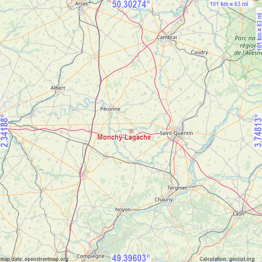
Monchy-Lagache GPS coordinates[2]
49° 51' 5.436" North, 3° 2' 42.036" East
| Map corner | latitude | longitude |
|---|---|---|
| Upper-left | 50.30274°, | 2.34188° |
| Center: | 49.85151°, | 3.04501° |
| Lower-right: | 49.39603°, | 3.74813° |
| Map W x H: | 100.8×100.8 km | = 62.6×62.6mi |
| max Lat: | 51.07786° ⇑7.4% North |
| Monchy-Lagache: | 49.85151° |
| min Lat: | ⇓92.6% South 41.3874° |
| min Long | Monchy-Lagache | max Long |
| -5.08615° | 3.04501° | 9.52242° |
| W 58.4%⇐ | ⇒41.6% E |
Elevation
Elevation of Monchy-Lagache is 76 m = 249 ft, and this is 117.7 m = 386 ft below average elevation for this country.
| Max E: |
2333 m = 7654 ft | 71% |
| Avg. | 193.7 m = 635 ft | |
| Monchy-Lagache | 76 m = 249 ft | |
Min E: |
-1 m = -3 ft | 29% |
See also: France elevation on elevation.city.
Geographical zone
Monchy-Lagache is located in North temperate zone (between Tropic of Cancer and the Arctic Circle). Distance of this North polar circle is 1858.2 km =1154.6 mi to North.| Distance of | km | miles | from Monchy-Lagache |
|---|---|---|---|
| North Pole | 4464.1 | 2773.9 | to North |
| Arctic Circle | 1858.2 | 1154.6 | to North |
| Tropic Cancer | 2937 | 1825 | to South |
| Equator | 5543 | 3444.3 | to South |


Nearby cities:
15 places around Monchy-Lagache: (largest is in red/bold)
• Athies
4.5 km =2.8 mi,  273°
273°
• Cartigny
7.1 km =4.4 mi,  341°
341°
• Doingt
9.5 km =5.9 mi,  324°
324°
• Eppeville
12.3 km =7.6 mi,  177°
177°
• Estrées-Mons
3.9 km =2.4 mi, 318°
• Ham
11.8 km =7.3 mi,  170°
170°
• Holnon
12.2 km =7.6 mi,  85°
85°
• Matigny
6.7 km =4.2 mi,  203°
203°
• Mesnil-Saint-Nicaise
12.1 km =7.5 mi,  227°
227°
• Péronne
11.9 km =7.4 mi, 319°
• Roisel
11.4 km =7.1 mi,  20°
20°
• Savy
11 km =6.8 mi,  102°
102°
• Vermand
8 km =5 mi,  70°
70°
• Voyennes
9.9 km =6.2 mi,  205°
205°
• Étreillers
8.6 km =5.3 mi,  105°
105°
Sources, notices
• [Note1] Compared only with cities in France existing in our database
• [Src1] Map data: © OpenStreetMap contributors (CC-BY-SA)
• [Src2] Other city data from geonames.org with taken over terms of usage.
• [Src3] Geographical zone / Annual Mean Temperature by Robert A. Rohde @ Wikipedia
