Savy geodata
Savy (Hauts-de-France) is a populated place; located in France in Europe/Paris (GMT+2) time zone. With population of 715 people, there are 11591 cities with bigger population in this country. Compared to other cities in France, 92.5% of cities are located further ↓South; 60.5% of cities are located further ←West and 59.1% of cities have higher elevation than Savy. Note1
Administrative division(s):
- Level 1: Hauts-de-France
- Level 2: Département de l'Aisne
- Level 3: Arrondissement de Saint-Quentin
- Level 4: Savy


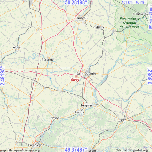
Savy GPS coordinates[2]
49° 49' 49.98" North, 3° 11' 42.288" East
| Map corner | latitude | longitude |
|---|---|---|
| Upper-left | 50.28198°, | 2.49195° |
| Center: | 49.83055°, | 3.19508° |
| Lower-right: | 49.37487°, | 3.8982° |
| Map W x H: | 100.9×100.9 km | = 62.7×62.7mi |
| max Lat: | 51.07786° ⇑7.5% North |
| Savy: | 49.83055° |
| min Lat: | ⇓92.5% South 41.3874° |
| min Long | Savy | max Long |
| -5.08615° | 3.19508° | 9.52242° |
| W 60.5%⇐ | ⇒39.5% E |
Elevation
Elevation of Savy is 105 m = 344 ft, and this is 88.7 m = 291 ft below average elevation for this country.
| Max E: |
2333 m = 7654 ft | 59.1% |
| Avg. | 193.7 m = 635 ft | |
| Savy | 105 m = 344 ft | |
Min E: |
-1 m = -3 ft | 40.9% |
See also: France elevation on elevation.city.
Geographical zone
Savy is located in North temperate zone (between Tropic of Cancer and the Arctic Circle). Distance of this North polar circle is 1860.5 km =1156.1 mi to North.| Distance of | km | miles | from Savy |
|---|---|---|---|
| North Pole | 4466.4 | 2775.3 | to North |
| Arctic Circle | 1860.5 | 1156.1 | to North |
| Tropic Cancer | 2934.7 | 1823.5 | to South |
| Equator | 5540.6 | 3442.8 | to South |


Nearby cities:
15 places around Savy: (largest is in red/bold)
• Clastres
9.8 km =6.1 mi,  163°
163°
• Essigny-le-Grand
8.3 km =5.2 mi,  134°
134°
• Fayet
5.9 km =3.7 mi,  44°
44°
• Gauchy
5.6 km =3.5 mi,  93°
93°
• Gricourt
7.2 km =4.5 mi,  28°
28°
• Grugies
5.6 km =3.5 mi,  111°
111°
• Harly
8.3 km =5.2 mi,  84°
84°
• Holnon
3.7 km =2.3 mi,  23°
23°
• Omissy
9.9 km =6.2 mi,  58°
58°
• Saint-Quentin
6.9 km =4.3 mi,  72°
72°
• Saint-Simon
9.5 km =5.9 mi,  187°
187°
• Seraucourt-le-Grand
5.5 km =3.4 mi, 163°
• Urvillers
9.4 km =5.8 mi,  118°
118°
• Vermand
6 km =3.7 mi,  326°
326°
• Étreillers
2.5 km =1.6 mi,  270°
270°
Sources, notices
• [Note1] Compared only with cities in France existing in our database
• [Src1] Map data: © OpenStreetMap contributors (CC-BY-SA)
• [Src2] Other city data from geonames.org with taken over terms of usage.
• [Src3] Geographical zone / Annual Mean Temperature by Robert A. Rohde @ Wikipedia
