Pesmes geodata
Pesmes (Bourgogne-Franche-Comté) is a populated place; located in France in Europe/Paris (GMT+2) time zone. With population of 1,117 people, there are 8027 cities with bigger population in this country. Compared to other cities in France, 51.8% of cities are located further ↑North; 83.5% of cities are located further ←West and 69% of cities have lower elevation than Pesmes. Note1
Administrative division(s):
- Level 1: Bourgogne-Franche-Comté
- Level 2: Département de la Haute-Saône
- Level 3: Arrondissement de Vesoul
- Level 4: Pesmes


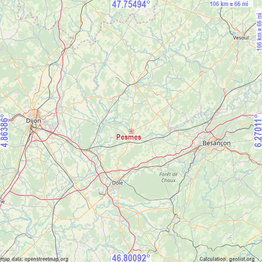
Pesmes GPS coordinates[2]
47° 16' 48.288" North, 5° 34' 1.128" East
| Map corner | latitude | longitude |
|---|---|---|
| Upper-left | 47.75494°, | 4.86386° |
| Center: | 47.28008°, | 5.56698° |
| Lower-right: | 46.80092°, | 6.27011° |
| Map W x H: | 106.1×106.1 km | = 65.9×65.9mi |
| max Lat: | 51.07786° ⇑51.8% North |
| Pesmes: | 47.28008° |
| min Lat: | ⇓48.2% South 41.3874° |
| min Long | Pesmes | max Long |
| -5.08615° | 5.56698° | 9.52242° |
| W 83.5%⇐ | ⇒16.5% E |
Elevation
Elevation of Pesmes is 214 m = 702 ft, and this is 20.3 m = 67 ft above average elevation for this country.
| Max E: |
2333 m = 7654 ft | 31% |
| Pesmes | 214 m 702 ft | |
| Avg. | 193.7 m = 635 ft | |
Min E: |
-1 m = -3 ft | 69% |
See also: France elevation on elevation.city.
Geographical zone
Pesmes is located in North temperate zone (between Tropic of Cancer and the Arctic Circle). Distance of this North polar circle is 2144.1 km =1332.3 mi to North.| Distance of | km | miles | from Pesmes |
|---|---|---|---|
| North Pole | 4750 | 2951.5 | to North |
| Arctic Circle | 2144.1 | 1332.3 | to North |
| Tropic Cancer | 2651.1 | 1647.3 | to South |
| Equator | 5257.1 | 3266.6 | to South |


Nearby cities:
15 places around Pesmes: (largest is in red/bold)
• Athée
15.7 km =9.8 mi,  249°
249°
• Authume
17.7 km =11 mi,  196°
196°
• Auxonne
16.7 km =10.4 mi,  234°
234°
• Gray
18.5 km =11.5 mi,  5°
5°
• Gray-la-Ville
17.7 km =11 mi,  1°
1°
• Lamarche-sur-Saône
13.7 km =8.5 mi,  265°
265°
• Mantoche
15.7 km =9.8 mi,  349°
349°
• Marnay
15.6 km =9.7 mi,  85°
85°
• Moissey
9.8 km =6.1 mi, 199°
• Orchamps
16.3 km =10.1 mi,  154°
154°
• Pontailler-sur-Saône
11.8 km =7.3 mi,  283°
283°
• Rochefort-sur-Nenon
17.2 km =10.7 mi,  181°
181°
• Valay
8.4 km =5.2 mi,  39°
39°
• Villers-les-Pots
17.8 km =11.1 mi, 246°
• Évans
18.9 km =11.7 mi,  126°
126°
Sources, notices
• [Note1] Compared only with cities in France existing in our database
• [Src1] Map data: © OpenStreetMap contributors (CC-BY-SA)
• [Src2] Other city data from geonames.org with taken over terms of usage.
• [Src3] Geographical zone / Annual Mean Temperature by Robert A. Rohde @ Wikipedia
