Modane geodata
Modane (Auvergne-Rhône-Alpes) is a populated place; located in France in Europe/Paris (GMT+2) time zone. With population of 4,086 people, there are 2405 cities with bigger population in this country. Compared to other cities in France, 77.4% of cities are located further ↑North; 92.8% of cities are located further ←West and 99.4% of cities have lower elevation than Modane. Note1
Administrative division(s):
- Level 1: Auvergne-Rhône-Alpes
- Level 2: Savoie
- Level 3: Arrondissement de Saint-Jean-de-Maurienne
- Level 4: Modane


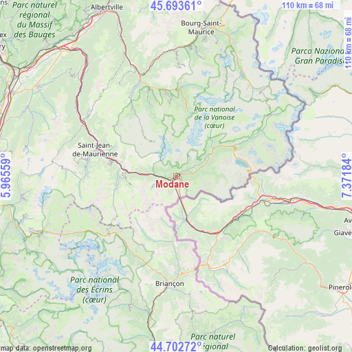
Modane GPS coordinates[2]
45° 12' 1.152" North, 6° 40' 7.356" East
| Map corner | latitude | longitude |
|---|---|---|
| Upper-left | 45.69361°, | 5.96559° |
| Center: | 45.20032°, | 6.66871° |
| Lower-right: | 44.70272°, | 7.37184° |
| Map W x H: | 110.2×110.2 km | = 68.5×68.5mi |
| max Lat: | 51.07786° ⇑77.4% North |
| Modane: | 45.20032° |
| min Lat: | ⇓22.6% South 41.3874° |
| min Long | Modane | max Long |
| -5.08615° | 6.66871° | 9.52242° |
| W 92.8%⇐ | ⇒7.2% E |
Elevation
Elevation of Modane is 1097 m = 3599 ft, and this is 903.3 m = 2964 ft above average elevation for this country.
| Max E: |
2333 m = 7654 ft | 0.59999999999999% |
| Modane | 1097 m 3599 ft | |
| Avg. | 193.7 m = 635 ft | |
Min E: |
-1 m = -3 ft | 99.4% |
See also: France elevation on elevation.city.
Geographical zone
Modane is located in North temperate zone (between Tropic of Cancer and the Arctic Circle). Distance of this North polar circle is 2375.4 km =1476 mi to North.| Distance of | km | miles | from Modane |
|---|---|---|---|
| North Pole | 4981.3 | 3095.2 | to North |
| Arctic Circle | 2375.4 | 1476 | to North |
| Tropic Cancer | 2419.9 | 1503.7 | to South |
| Equator | 5025.8 | 3122.9 | to South |


Nearby cities:
15 places around Modane: (largest is in red/bold)
• Albanne
19.5 km =12.1 mi,  271°
271°
• Aussois
6.6 km =4.1 mi,  61°
61°
• Courchevel
24 km =14.9 mi,  353°
353°
• Fourneaux
1.9 km =1.2 mi,  233°
233°
• Lanslebourg-Mont-Cenis
18.8 km =11.7 mi, 59°
• Méribel
25.2 km =15.7 mi,  341°
341°
• Pralognan-la-Vanoise
20.8 km =12.9 mi,  10°
10°
• Saint-Martin-de-Belleville
23.9 km =14.9 mi,  327°
327°
• Saint-Martin-de-la-Porte
17.9 km =11.1 mi,  283°
283°
• Saint-Michel-de-Maurienne
15.8 km =9.8 mi, 277°
• Val Thorens
12.7 km =7.9 mi, 328°
• Valloire
19.1 km =11.9 mi,  258°
258°
• Valmeinier
14.8 km =9.2 mi, 263°
• Villargondran
23.9 km =14.9 mi,  287°
287°
• Villarodin
3.3 km =2.1 mi,  75°
75°
Sources, notices
• [Note1] Compared only with cities in France existing in our database
• [Src1] Map data: © OpenStreetMap contributors (CC-BY-SA)
• [Src2] Other city data from geonames.org with taken over terms of usage.
• [Src3] Geographical zone / Annual Mean Temperature by Robert A. Rohde @ Wikipedia
