Fourneaux geodata
Fourneaux (Auvergne-Rhône-Alpes) is a populated place; located in France in Europe/Paris (GMT+2) time zone. With population of 956 people, there are 9159 cities with bigger population in this country. Compared to other cities in France, 77.5% of cities are located further ↑North; 92.7% of cities are located further ←West and 99.6% of cities have lower elevation than Fourneaux. Note1
Administrative division(s):
- Level 1: Auvergne-Rhône-Alpes
- Level 2: Savoie
- Level 3: Arrondissement de Saint-Jean-de-Maurienne
- Level 4: Fourneaux


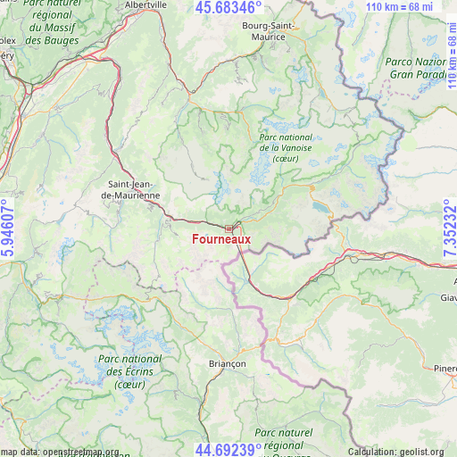
Fourneaux GPS coordinates[2]
45° 11' 24.288" North, 6° 38' 57.084" East
| Map corner | latitude | longitude |
|---|---|---|
| Upper-left | 45.68346°, | 5.94607° |
| Center: | 45.19008°, | 6.64919° |
| Lower-right: | 44.69239°, | 7.35232° |
| Map W x H: | 110.2×110.2 km | = 68.5×68.5mi |
| max Lat: | 51.07786° ⇑77.5% North |
| Fourneaux: | 45.19008° |
| min Lat: | ⇓22.5% South 41.3874° |
| min Long | Fourneaux | max Long |
| -5.08615° | 6.64919° | 9.52242° |
| W 92.7%⇐ | ⇒7.3% E |
Elevation
Elevation of Fourneaux is 1187 m = 3894 ft, and this is 993.3 m = 3259 ft above average elevation for this country.
| Max E: |
2333 m = 7654 ft | 0.40000000000001% |
| Fourneaux | 1187 m 3894 ft | |
| Avg. | 193.7 m = 635 ft | |
Min E: |
-1 m = -3 ft | 99.6% |
See also: France elevation on elevation.city.
Geographical zone
Fourneaux is located in North temperate zone (between Tropic of Cancer and the Arctic Circle). Distance of this North polar circle is 2376.5 km =1476.7 mi to North.| Distance of | km | miles | from Fourneaux |
|---|---|---|---|
| North Pole | 4982.4 | 3095.9 | to North |
| Arctic Circle | 2376.5 | 1476.7 | to North |
| Tropic Cancer | 2418.7 | 1502.9 | to South |
| Equator | 5024.7 | 3122.2 | to South |


Nearby cities:
15 places around Fourneaux: (largest is in red/bold)
• Albanne
18 km =11.2 mi,  275°
275°
• Aussois
8.4 km =5.2 mi,  59°
59°
• Courchevel
25.1 km =15.6 mi,  357°
357°
• Lanslebourg-Mont-Cenis
20.7 km =12.9 mi, 59°
• Modane
1.9 km =1.2 mi,  53°
53°
• Pralognan-la-Vanoise
22.2 km =13.8 mi,  13°
13°
• Saint-Jean-de-Maurienne
25.1 km =15.6 mi,  292°
292°
• Saint-Martin-de-Belleville
24.1 km =15 mi,  332°
332°
• Saint-Martin-de-la-Porte
16.8 km =10.4 mi, 288°
• Saint-Michel-de-Maurienne
14.5 km =9 mi, 283°
• Val Thorens
13 km =8.1 mi,  336°
336°
• Valloire
17.4 km =10.8 mi,  260°
260°
• Valmeinier
13.2 km =8.2 mi,  267°
267°
• Villargondran
22.9 km =14.2 mi, 291°
• Villarodin
5.1 km =3.2 mi,  67°
67°
Sources, notices
• [Note1] Compared only with cities in France existing in our database
• [Src1] Map data: © OpenStreetMap contributors (CC-BY-SA)
• [Src2] Other city data from geonames.org with taken over terms of usage.
• [Src3] Geographical zone / Annual Mean Temperature by Robert A. Rohde @ Wikipedia
