Saint-Michel-de-Maurienne geodata
Saint-Michel-de-Maurienne (Auvergne-Rhône-Alpes) is a populated place; located in France in Europe/Paris (GMT+2) time zone. With population of 3,174 people, there are 3068 cities with bigger population in this country. Compared to other cities in France, 77.2% of cities are located further ↑North; 91.5% of cities are located further ←West and 98.7% of cities have lower elevation than Saint-Michel-de-Maurienne. Note1
Administrative division(s):
- Level 1: Auvergne-Rhône-Alpes
- Level 2: Savoie
- Level 3: Arrondissement de Saint-Jean-de-Maurienne
- Level 4: Saint-Michel-de-Maurienne
Current local time in Saint-Michel-de-Maurienne:
11:09 AM, WednesdayDifference from your time zone: hours


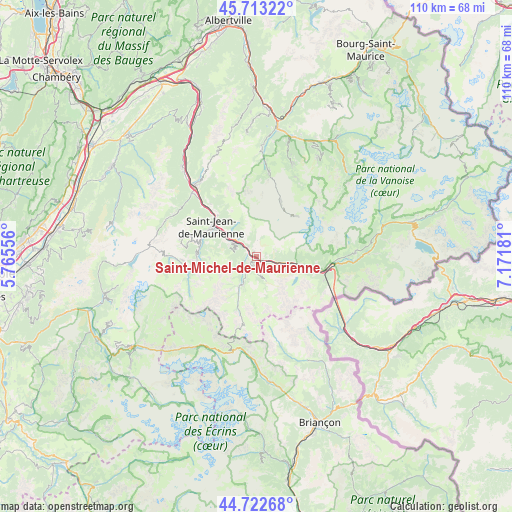
Saint-Michel-de-Maurienne GPS coordinates[2]
45° 13' 12.396" North, 6° 28' 7.248" East
| Map corner | latitude | longitude |
|---|---|---|
| Upper-left | 45.71322°, | 5.76556° |
| Center: | 45.22011°, | 6.46868° |
| Lower-right: | 44.72268°, | 7.17181° |
| Map W x H: | 110.1×110.1 km | = 68.4×68.4mi |
| max Lat: | 51.07786° ⇑77.2% North |
| Saint-Michel-de-Maurienne: | 45.22011° |
| min Lat: | ⇓22.8% South 41.3874° |
| min Long | Saint-Michel-de | max Long |
| -5.08615° | 6.46868° | 9.52242° |
| W 91.5%⇐ | ⇒8.5% E |
Elevation
Elevation of Saint-Michel-de-Maurienne is 906 m = 2972 ft, and this is 712.3 m = 2337 ft above average elevation for this country.
| Max E: |
2333 m = 7654 ft | 1.3% |
| Saint-Michel-de-Maurienne | 906 m 2972 ft | |
| Avg. | 193.7 m = 635 ft | |
Min E: |
-1 m = -3 ft | 98.7% |
See also: France elevation on elevation.city.
Geographical zone
Saint-Michel-de-Maurienne is located in North temperate zone (between Tropic of Cancer and the Arctic Circle). Distance of this North polar circle is 2373.2 km =1474.6 mi to North.| Distance of | km | miles | from Saint-Michel-de-Maurienne |
|---|---|---|---|
| North Pole | 4979.1 | 3093.9 | to North |
| Arctic Circle | 2373.2 | 1474.6 | to North |
| Tropic Cancer | 2422.1 | 1505 | to South |
| Equator | 5028 | 3124.3 | to South |


Nearby cities:
15 places around Saint-Michel-de-Maurienne: (largest is in red/bold)
• Albanne
4.1 km =2.5 mi,  247°
247°
• Fontcouverte-la Toussuire
13.6 km =8.5 mi,  284°
284°
• Fourneaux
14.5 km =9 mi,  103°
103°
• Hermillon
12 km =7.5 mi,  315°
315°
• Modane
15.8 km =9.8 mi, 97°
• Saint-Avre
19.7 km =12.2 mi, 319°
• Saint-Jean-de-Maurienne
10.9 km =6.8 mi,  304°
304°
• Saint-Martin-de-Belleville
18.2 km =11.3 mi,  9°
9°
• Saint-Martin-de-la-Porte
2.7 km =1.7 mi, 319°
• Sainte-Marie-de-Cuines
18.4 km =11.4 mi, 315°
• Val Thorens
12.5 km =7.8 mi,  46°
46°
• Valloire
6.8 km =4.2 mi,  206°
206°
• Valmeinier
3.9 km =2.4 mi,  165°
165°
• Villargondran
8.7 km =5.4 mi, 304°
• Villarodin
18.9 km =11.7 mi,  94°
94°
Sources, notices
• [Note1] Compared only with cities in France existing in our database
• [Src1] Map data: © OpenStreetMap contributors (CC-BY-SA)
• [Src2] Other city data from geonames.org with taken over terms of usage.
• [Src3] Geographical zone / Annual Mean Temperature by Robert A. Rohde @ Wikipedia
