Valloire geodata
Valloire (Auvergne-Rhône-Alpes) is a populated place; located in France in Europe/Paris (GMT+2) time zone. With population of 1,346 people, there are 6833 cities with bigger population in this country. Compared to other cities in France, 77.8% of cities are located further ↑North; 91.3% of cities are located further ←West and 99.8% of cities have lower elevation than Valloire. Note1
Administrative division(s):
- Level 1: Auvergne-Rhône-Alpes
- Level 2: Savoie
- Level 3: Arrondissement de Saint-Jean-de-Maurienne
- Level 4: Valloire


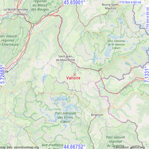
Valloire GPS coordinates[2]
45° 9' 55.512" North, 6° 25' 47.928" East
| Map corner | latitude | longitude |
|---|---|---|
| Upper-left | 45.65901°, | 5.72685° |
| Center: | 45.16542°, | 6.42998° |
| Lower-right: | 44.66752°, | 7.1331° |
| Map W x H: | 110.2×110.2 km | = 68.5×68.5mi |
| max Lat: | 51.07786° ⇑77.8% North |
| Valloire: | 45.16542° |
| min Lat: | ⇓22.2% South 41.3874° |
| min Long | Valloire | max Long |
| -5.08615° | 6.42998° | 9.52242° |
| W 91.3%⇐ | ⇒8.7% E |
Elevation
Elevation of Valloire is 1404 m = 4606 ft, and this is 1210.3 m = 3971 ft above average elevation for this country.
| Max E: |
2333 m = 7654 ft | 0.2% |
| Valloire | 1404 m 4606 ft | |
| Avg. | 193.7 m = 635 ft | |
Min E: |
-1 m = -3 ft | 99.8% |
See also: France elevation on elevation.city.
Geographical zone
Valloire is located in North temperate zone (between Tropic of Cancer and the Arctic Circle). Distance of this North polar circle is 2379.3 km =1478.4 mi to North.| Distance of | km | miles | from Valloire |
|---|---|---|---|
| North Pole | 4985.1 | 3097.6 | to North |
| Arctic Circle | 2379.3 | 1478.4 | to North |
| Tropic Cancer | 2416 | 1501.2 | to South |
| Equator | 5021.9 | 3120.5 | to South |


Nearby cities:
15 places around Valloire: (largest is in red/bold)
• Albanne
4.5 km =2.8 mi,  350°
350°
• Fontcouverte-la Toussuire
13.9 km =8.6 mi,  312°
312°
• Fourneaux
17.4 km =10.8 mi,  80°
80°
• Hermillon
15.7 km =9.8 mi,  339°
339°
• Le Monêtier-les-Bains
22 km =13.7 mi,  163°
163°
• Modane
19.1 km =11.9 mi, 78°
• Saint-Avre
23.2 km =14.4 mi, 335°
• Saint-Jean-de-Maurienne
13.6 km =8.5 mi,  333°
333°
• Saint-Martin-de-la-Porte
8.2 km =5.1 mi,  9°
9°
• Saint-Michel-de-Maurienne
6.8 km =4.2 mi,  26°
26°
• Sainte-Marie-de-Cuines
21.6 km =13.4 mi, 332°
• Val Thorens
19 km =11.8 mi,  39°
39°
• Valmeinier
4.6 km =2.9 mi,  60°
60°
• Villargondran
11.8 km =7.3 mi, 339°
• Villarodin
22.4 km =13.9 mi, 77°
Sources, notices
• [Note1] Compared only with cities in France existing in our database
• [Src1] Map data: © OpenStreetMap contributors (CC-BY-SA)
• [Src2] Other city data from geonames.org with taken over terms of usage.
• [Src3] Geographical zone / Annual Mean Temperature by Robert A. Rohde @ Wikipedia
