Meyenheim geodata
Meyenheim (Grand Est) is a populated place; located in France in Europe/Paris (GMT+2) time zone. With population of 1,136 people, there are 7911 cities with bigger population in this country. Compared to other cities in France, 57.8% of cities are located further ↓South; 97% of cities are located further ←West and 68.1% of cities have lower elevation than Meyenheim. Note1
Administrative division(s):
- Level 1: Grand Est
- Level 2: Haut-Rhin
- Level 3: Arrondissement de Thann-Guebwiller
- Level 4: Meyenheim


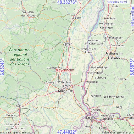
Meyenheim GPS coordinates[2]
47° 54' 49.104" North, 7° 21' 20.16" East
| Map corner | latitude | longitude |
|---|---|---|
| Upper-left | 48.38276°, | 6.65248° |
| Center: | 47.91364°, | 7.3556° |
| Lower-right: | 47.44022°, | 8.05873° |
| Map W x H: | 104.8×104.8 km | = 65.1×65.1mi |
| max Lat: | 51.07786° ⇑42.2% North |
| Meyenheim: | 47.91364° |
| min Lat: | ⇓57.8% South 41.3874° |
| min Long | Meyenheim | max Long |
| -5.08615° | 7.3556° | 9.52242° |
| W 97%⇐ | ⇒3% E |
Elevation
Elevation of Meyenheim is 210 m = 689 ft, and this is 16.3 m = 53 ft above average elevation for this country.
| Max E: |
2333 m = 7654 ft | 31.9% |
| Meyenheim | 210 m 689 ft | |
| Avg. | 193.7 m = 635 ft | |
Min E: |
-1 m = -3 ft | 68.1% |
See also: France elevation on elevation.city.
Geographical zone
Meyenheim is located in North temperate zone (between Tropic of Cancer and the Arctic Circle). Distance of this North polar circle is 2073.7 km =1288.5 mi to North.| Distance of | km | miles | from Meyenheim |
|---|---|---|---|
| North Pole | 4679.6 | 2907.8 | to North |
| Arctic Circle | 2073.7 | 1288.5 | to North |
| Tropic Cancer | 2721.6 | 1691.1 | to South |
| Equator | 5327.5 | 3310.4 | to South |


Nearby cities:
15 places around Meyenheim: (largest is in red/bold)
• Bergholtz
8.1 km =5 mi,  272°
272°
• Ensisheim
5.3 km =3.3 mi,  184°
184°
• Feldkirch
8.1 km =5 mi,  228°
228°
• Gundolsheim
4.9 km =3 mi,  291°
291°
• Hirtzfelden
6.7 km =4.2 mi,  92°
92°
• Issenheim
7.8 km =4.8 mi,  261°
261°
• Merxheim
4.5 km =2.8 mi, 266°
• Niederhergheim
8.6 km =5.3 mi,  21°
21°
• Oberentzen
3.6 km =2.2 mi, 24°
• Oberhergheim
6.6 km =4.1 mi,  26°
26°
• Raedersheim
6.1 km =3.8 mi,  243°
243°
• Rouffach
6.4 km =4 mi,  319°
319°
• Rustenhart
8.5 km =5.3 mi,  68°
68°
• Réguisheim
2 km =1.2 mi,  185°
185°
• Ungersheim
5.3 km =3.3 mi,  222°
222°
Sources, notices
• [Note1] Compared only with cities in France existing in our database
• [Src1] Map data: © OpenStreetMap contributors (CC-BY-SA)
• [Src2] Other city data from geonames.org with taken over terms of usage.
• [Src3] Geographical zone / Annual Mean Temperature by Robert A. Rohde @ Wikipedia
