Meursac geodata
Meursac (Nouvelle-Aquitaine) is a populated place; located in France in Europe/Paris (GMT+2) time zone. With population of 1,076 people, there are 8284 cities with bigger population in this country. Compared to other cities in France, 71.7% of cities are located further ↑North; 86.5% of cities are located further →East and 90.3% of cities have higher elevation than Meursac. Note1
Administrative division(s):
- Level 1: Nouvelle-Aquitaine
- Level 2: Charente-Maritime
- Level 3: Arrondissement de Saintes
- Level 4: Meursac


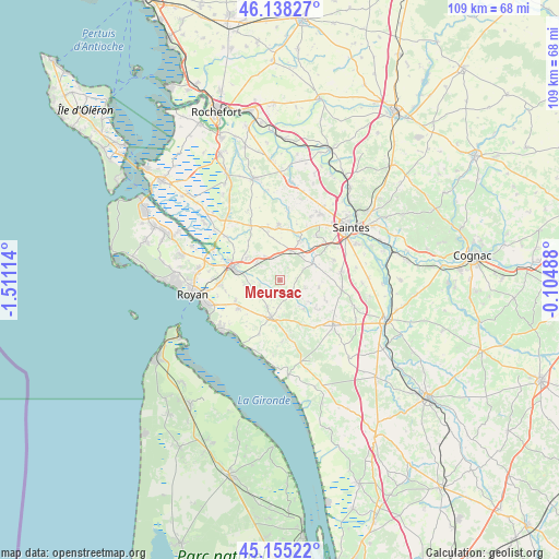
Meursac GPS coordinates[2]
45° 38' 56.04" North, 0° 48' 28.836" West
| Map corner | latitude | longitude |
|---|---|---|
| Upper-left | 46.13827°, | -1.51114° |
| Center: | 45.6489°, | -0.80801° |
| Lower-right: | 45.15522°, | -0.10488° |
| Map W x H: | 109.3×109.3 km | = 67.9×67.9mi |
| max Lat: | 51.07786° ⇑71.7% North |
| Meursac: | 45.6489° |
| min Lat: | ⇓28.3% South 41.3874° |
| min Long | Meursac | max Long |
| -5.08615° | -0.80801° | 9.52242° |
| W 13.5%⇐ | ⇒86.5% E |
Elevation
Elevation of Meursac is 29 m = 95 ft, and this is 164.7 m = 540 ft below average elevation for this country.
| Max E: |
2333 m = 7654 ft | 90.3% |
| Avg. | 193.7 m = 635 ft | |
| Meursac | 29 m = 95 ft | |
Min E: |
-1 m = -3 ft | 9.7% |
See also: France elevation on elevation.city.
Geographical zone
Meursac is located in North temperate zone (between Tropic of Cancer and the Arctic Circle). Distance of this North polar circle is 2325.5 km =1445 mi to North.| Distance of | km | miles | from Meursac |
|---|---|---|---|
| North Pole | 4931.4 | 3064.2 | to North |
| Arctic Circle | 2325.5 | 1445 | to North |
| Tropic Cancer | 2469.8 | 1534.7 | to South |
| Equator | 5075.7 | 3153.9 | to South |


Nearby cities:
15 places around Meursac: (largest is in red/bold)
• Corme-Royal
10.6 km =6.6 mi,  357°
357°
• Corme-Écluse
4.3 km =2.7 mi,  241°
241°
• Cozes
7.5 km =4.7 mi,  194°
194°
• Cravans
9.5 km =5.9 mi,  127°
127°
• Grézac
5.7 km =3.5 mi,  206°
206°
• Le Chay
6.9 km =4.3 mi,  260°
260°
• Montpellier-de-Médillan
5.2 km =3.2 mi,  107°
107°
• Rioux
7.7 km =4.8 mi,  100°
100°
• Rétaud
7 km =4.3 mi,  62°
62°
• Sablonceaux
9.2 km =5.7 mi,  317°
317°
• Saint-André-de-Lidon
7.2 km =4.5 mi,  139°
139°
• Saint-Romain-de-Benet
5.6 km =3.5 mi,  326°
326°
• Saujon
9.6 km =6 mi,  286°
286°
• Semussac
10 km =6.2 mi, 237°
• Varzay
8.7 km =5.4 mi,  43°
43°
Sources, notices
• [Note1] Compared only with cities in France existing in our database
• [Src1] Map data: © OpenStreetMap contributors (CC-BY-SA)
• [Src2] Other city data from geonames.org with taken over terms of usage.
• [Src3] Geographical zone / Annual Mean Temperature by Robert A. Rohde @ Wikipedia
