Corme-Écluse geodata
Corme-Écluse (Nouvelle-Aquitaine) is a populated place; located in France in Europe/Paris (GMT+2) time zone. With population of 810 people, there are 10481 cities with bigger population in this country. Compared to other cities in France, 72.1% of cities are located further ↑North; 86.9% of cities are located further →East and 95% of cities have higher elevation than Corme-Écluse. Note1
Administrative division(s):
- Level 1: Nouvelle-Aquitaine
- Level 2: Charente-Maritime
- Level 3: Arrondissement de Saintes
- Level 4: Corme-Écluse


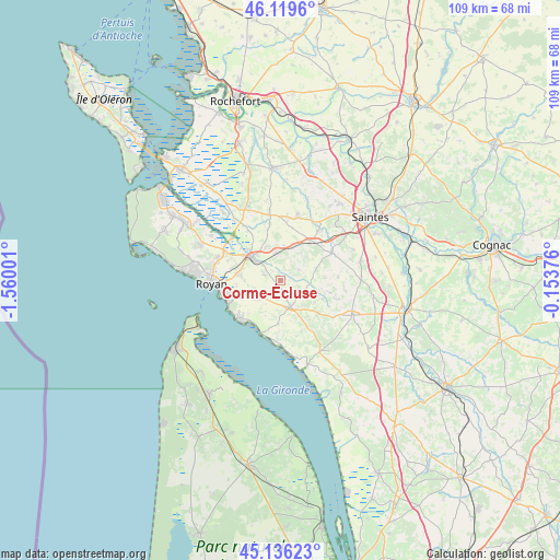
Corme-Écluse GPS coordinates[2]
45° 37' 48.252" North, 0° 51' 24.804" West
| Map corner | latitude | longitude |
|---|---|---|
| Upper-left | 46.1196°, | -1.56001° |
| Center: | 45.63007°, | -0.85689° |
| Lower-right: | 45.13623°, | -0.15376° |
| Map W x H: | 109.3×109.3 km | = 67.9×67.9mi |
| max Lat: | 51.07786° ⇑72.1% North |
| Corme-Écluse: | 45.63007° |
| min Lat: | ⇓27.9% South 41.3874° |
| min Long | Corme-Écluse | max Long |
| -5.08615° | -0.85689° | 9.52242° |
| W 13.1%⇐ | ⇒86.9% E |
Elevation
Elevation of Corme-Écluse is 17 m = 56 ft, and this is 176.7 m = 580 ft below average elevation for this country.
| Max E: |
2333 m = 7654 ft | 95% |
| Avg. | 193.7 m = 635 ft | |
| Corme-Écluse | 17 m = 56 ft | |
Min E: |
-1 m = -3 ft | 5% |
See also: France elevation on elevation.city.
Geographical zone
Corme-Écluse is located in North temperate zone (between Tropic of Cancer and the Arctic Circle). Distance of this North polar circle is 2327.6 km =1446.3 mi to North.| Distance of | km | miles | from Corme-Écluse |
|---|---|---|---|
| North Pole | 4933.5 | 3065.5 | to North |
| Arctic Circle | 2327.6 | 1446.3 | to North |
| Tropic Cancer | 2467.7 | 1533.4 | to South |
| Equator | 5073.6 | 3152.6 | to South |


Nearby cities:
15 places around Corme-Écluse: (largest is in red/bold)
• Arces
8.9 km =5.5 mi,  184°
184°
• Cozes
5.5 km =3.4 mi,  159°
159°
• Grézac
3.2 km =2 mi, 157°
• Le Chay
3.2 km =2 mi,  287°
287°
• Meschers-sur-Gironde
10.9 km =6.8 mi,  224°
224°
• Meursac
4.3 km =2.7 mi,  61°
61°
• Montpellier-de-Médillan
8.7 km =5.4 mi,  86°
86°
• Médis
8.4 km =5.2 mi,  280°
280°
• Rétaud
11.4 km =7.1 mi, 62°
• Sablonceaux
9.2 km =5.7 mi,  344°
344°
• Saint-André-de-Lidon
9.1 km =5.7 mi,  111°
111°
• Saint-Romain-de-Benet
6.9 km =4.3 mi,  6°
6°
• Saujon
7.2 km =4.5 mi,  311°
311°
• Semussac
5.7 km =3.5 mi,  234°
234°
• Épargnes
10.7 km =6.6 mi, 156°
Sources, notices
• [Note1] Compared only with cities in France existing in our database
• [Src1] Map data: © OpenStreetMap contributors (CC-BY-SA)
• [Src2] Other city data from geonames.org with taken over terms of usage.
• [Src3] Geographical zone / Annual Mean Temperature by Robert A. Rohde @ Wikipedia
