Metz-en-Couture geodata
Metz-en-Couture (Hauts-de-France) is a populated place; located in France in Europe/Paris (GMT+2) time zone. With population of 628 people, there are 12854 cities with bigger population in this country. Compared to other cities in France, 94% of cities are located further ↓South; 58.7% of cities are located further ←West and 52.6% of cities have higher elevation than Metz-en-Couture. Note1
Administrative division(s):
- Level 1: Hauts-de-France
- Level 2: Pas-de-Calais
- Level 3: Arras
- Level 4: Metz-en-Couture


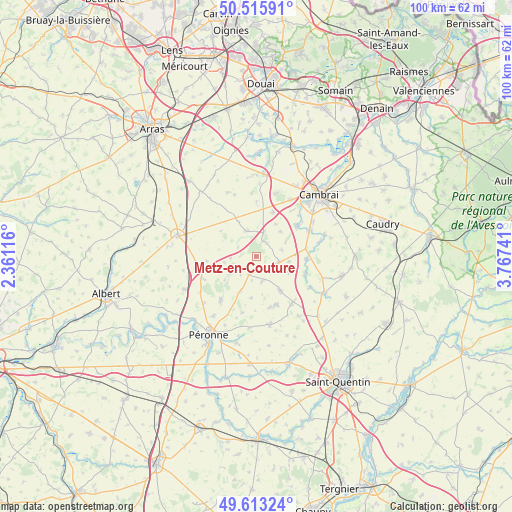
Metz-en-Couture GPS coordinates[2]
50° 4' 0.12" North, 3° 3' 51.408" East
| Map corner | latitude | longitude |
|---|---|---|
| Upper-left | 50.51591°, | 2.36116° |
| Center: | 50.0667°, | 3.06428° |
| Lower-right: | 49.61324°, | 3.76741° |
| Map W x H: | 100.4×100.4 km | = 62.4×62.4mi |
| max Lat: | 51.07786° ⇑6% North |
| Metz-en-Couture: | 50.0667° |
| min Lat: | ⇓94% South 41.3874° |
| min Long | Metz-en-Couture | max Long |
| -5.08615° | 3.06428° | 9.52242° |
| W 58.7%⇐ | ⇒41.3% E |
Elevation
Elevation of Metz-en-Couture is 123 m = 404 ft, and this is 70.7 m = 232 ft below average elevation for this country.
| Max E: |
2333 m = 7654 ft | 52.6% |
| Avg. | 193.7 m = 635 ft | |
| Metz-en-Couture | 123 m = 404 ft | |
Min E: |
-1 m = -3 ft | 47.4% |
See also: France elevation on elevation.city.
Geographical zone
Metz-en-Couture is located in North temperate zone (between Tropic of Cancer and the Arctic Circle). Distance of this North polar circle is 1834.3 km =1139.8 mi to North.| Distance of | km | miles | from Metz-en-Couture |
|---|---|---|---|
| North Pole | 4440.2 | 2759 | to North |
| Arctic Circle | 1834.3 | 1139.8 | to North |
| Tropic Cancer | 2961 | 1839.9 | to South |
| Equator | 5566.9 | 3459.1 | to South |


Nearby cities:
15 places around Metz-en-Couture: (largest is in red/bold)
• Beaumetz-lès-Cambrai
8.4 km =5.2 mi,  317°
317°
• Bertincourt
6.3 km =3.9 mi,  289°
289°
• Gouzeaucourt
4.4 km =2.7 mi,  105°
105°
• Graincourt-lès-Havrincourt
9.5 km =5.9 mi,  19°
19°
• Hermies
5.2 km =3.2 mi,  342°
342°
• Heudicourt
5.1 km =3.2 mi,  166°
166°
• Honnecourt-sur-Escaut
10.4 km =6.5 mi, 110°
• Marcoing
9.8 km =6.1 mi,  52°
52°
• Masnières
11.6 km =7.2 mi,  62°
62°
• Moislains
11.3 km =7 mi,  219°
219°
• Noyelles-sur-Escaut
11.3 km =7 mi, 48°
• Ronssoy
11.5 km =7.1 mi,  143°
143°
• Villers-Faucon
10.2 km =6.3 mi,  164°
164°
• Villers-Guislain
7.1 km =4.4 mi, 114°
• Épehy
8.9 km =5.5 mi,  146°
146°
Sources, notices
• [Note1] Compared only with cities in France existing in our database
• [Src1] Map data: © OpenStreetMap contributors (CC-BY-SA)
• [Src2] Other city data from geonames.org with taken over terms of usage.
• [Src3] Geographical zone / Annual Mean Temperature by Robert A. Rohde @ Wikipedia
