Heudicourt geodata
Heudicourt (Hauts-de-France) is a populated place; located in France in Europe/Paris (GMT+2) time zone. With population of 522 people, there are 14782 cities with bigger population in this country. Compared to other cities in France, 93.7% of cities are located further ↓South; 59% of cities are located further ←West and 53.8% of cities have higher elevation than Heudicourt. Note1
Administrative division(s):
- Level 1: Hauts-de-France
- Level 2: Somme
- Level 3: Arrondissement de Péronne
- Level 4: Heudicourt


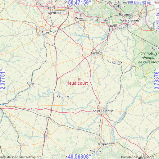
Heudicourt GPS coordinates[2]
50° 1' 19.056" North, 3° 4' 50.304" East
| Map corner | latitude | longitude |
|---|---|---|
| Upper-left | 50.47159°, | 2.37751° |
| Center: | 50.02196°, | 3.08064° |
| Lower-right: | 49.56808°, | 3.78376° |
| Map W x H: | 100.5×100.5 km | = 62.4×62.4mi |
| max Lat: | 51.07786° ⇑6.3% North |
| Heudicourt: | 50.02196° |
| min Lat: | ⇓93.7% South 41.3874° |
| min Long | Heudicourt | max Long |
| -5.08615° | 3.08064° | 9.52242° |
| W 59%⇐ | ⇒41% E |
Elevation
Elevation of Heudicourt is 120 m = 394 ft, and this is 73.7 m = 242 ft below average elevation for this country.
| Max E: |
2333 m = 7654 ft | 53.8% |
| Avg. | 193.7 m = 635 ft | |
| Heudicourt | 120 m = 394 ft | |
Min E: |
-1 m = -3 ft | 46.2% |
See also: France elevation on elevation.city.
Geographical zone
Heudicourt is located in North temperate zone (between Tropic of Cancer and the Arctic Circle). Distance of this North polar circle is 1839.3 km =1142.9 mi to North.| Distance of | km | miles | from Heudicourt |
|---|---|---|---|
| North Pole | 4445.1 | 2762.1 | to North |
| Arctic Circle | 1839.3 | 1142.9 | to North |
| Tropic Cancer | 2956 | 1836.8 | to South |
| Equator | 5561.9 | 3456 | to South |


Nearby cities:
15 places around Heudicourt: (largest is in red/bold)
• Bellicourt
12.9 km =8 mi,  121°
121°
• Bertincourt
10 km =6.2 mi,  315°
315°
• Gouy
12.7 km =7.9 mi,  100°
100°
• Gouzeaucourt
4.9 km =3 mi,  38°
38°
• Hargicourt
9.7 km =6 mi,  133°
133°
• Hermies
10.3 km =6.4 mi,  344°
344°
• Honnecourt-sur-Escaut
8.6 km =5.3 mi,  81°
81°
• Marcoing
12.9 km =8 mi,  30°
30°
• Metz-en-Couture
5.1 km =3.2 mi,  346°
346°
• Moislains
9.1 km =5.7 mi,  245°
245°
• Roisel
8.4 km =5.2 mi,  170°
170°
• Ronssoy
7.1 km =4.4 mi, 127°
• Villers-Faucon
5.1 km =3.2 mi,  163°
163°
• Villers-Guislain
5.7 km =3.5 mi,  68°
68°
• Épehy
4.5 km =2.8 mi, 122°
Sources, notices
• [Note1] Compared only with cities in France existing in our database
• [Src1] Map data: © OpenStreetMap contributors (CC-BY-SA)
• [Src2] Other city data from geonames.org with taken over terms of usage.
• [Src3] Geographical zone / Annual Mean Temperature by Robert A. Rohde @ Wikipedia
