Gouzeaucourt geodata
Gouzeaucourt (Hauts-de-France) is a populated place; located in France in Europe/Paris (GMT+2) time zone. With population of 1,284 people, there are 7106 cities with bigger population in this country. Compared to other cities in France, 93.9% of cities are located further ↓South; 59.6% of cities are located further ←West and 52.6% of cities have higher elevation than Gouzeaucourt. Note1
Administrative division(s):
- Level 1: Hauts-de-France
- Level 2: Nord
- Level 3: Arrondissement de Cambrai
- Level 4: Gouzeaucourt


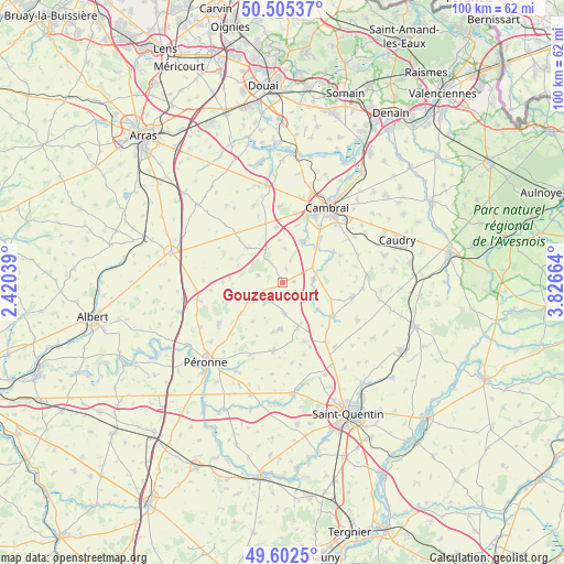
Gouzeaucourt GPS coordinates[2]
50° 3' 21.816" North, 3° 7' 24.636" East
| Map corner | latitude | longitude |
|---|---|---|
| Upper-left | 50.50537°, | 2.42039° |
| Center: | 50.05606°, | 3.12351° |
| Lower-right: | 49.6025°, | 3.82664° |
| Map W x H: | 100.4×100.4 km | = 62.4×62.4mi |
| max Lat: | 51.07786° ⇑6.1% North |
| Gouzeaucourt: | 50.05606° |
| min Lat: | ⇓93.9% South 41.3874° |
| min Long | Gouzeaucourt | max Long |
| -5.08615° | 3.12351° | 9.52242° |
| W 59.6%⇐ | ⇒40.4% E |
Elevation
Elevation of Gouzeaucourt is 123 m = 404 ft, and this is 70.7 m = 232 ft below average elevation for this country.
| Max E: |
2333 m = 7654 ft | 52.6% |
| Avg. | 193.7 m = 635 ft | |
| Gouzeaucourt | 123 m = 404 ft | |
Min E: |
-1 m = -3 ft | 47.4% |
See also: France elevation on elevation.city.
Geographical zone
Gouzeaucourt is located in North temperate zone (between Tropic of Cancer and the Arctic Circle). Distance of this North polar circle is 1835.5 km =1140.5 mi to North.| Distance of | km | miles | from Gouzeaucourt |
|---|---|---|---|
| North Pole | 4441.3 | 2759.7 | to North |
| Arctic Circle | 1835.5 | 1140.5 | to North |
| Tropic Cancer | 2959.8 | 1839.1 | to South |
| Equator | 5565.7 | 3458.4 | to South |


Nearby cities:
15 places around Gouzeaucourt: (largest is in red/bold)
• Bertincourt
10.7 km =6.6 mi,  288°
288°
• Graincourt-lès-Havrincourt
10.2 km =6.3 mi,  354°
354°
• Hermies
8.5 km =5.3 mi,  316°
316°
• Heudicourt
4.9 km =3 mi,  218°
218°
• Honnecourt-sur-Escaut
6 km =3.7 mi,  114°
114°
• Les Rues-des-Vignes
9.3 km =5.8 mi,  61°
61°
• Marcoing
8.1 km =5 mi,  26°
26°
• Masnières
8.9 km =5.5 mi,  42°
42°
• Metz-en-Couture
4.4 km =2.7 mi, 285°
• Noyelles-sur-Escaut
9.6 km =6 mi, 26°
• Ronssoy
8.5 km =5.3 mi,  162°
162°
• Rumilly-en-Cambrésis
10.4 km =6.5 mi, 40°
• Villers-Faucon
8.8 km =5.5 mi,  190°
190°
• Villers-Guislain
2.8 km =1.7 mi,  127°
127°
• Épehy
6.3 km =3.9 mi,  173°
173°
Sources, notices
• [Note1] Compared only with cities in France existing in our database
• [Src1] Map data: © OpenStreetMap contributors (CC-BY-SA)
• [Src2] Other city data from geonames.org with taken over terms of usage.
• [Src3] Geographical zone / Annual Mean Temperature by Robert A. Rohde @ Wikipedia
