Masnières geodata
Masnières (Hauts-de-France) is a populated place; located in France in Europe/Paris (GMT+2) time zone. With population of 2,593 people, there are 3764 cities with bigger population in this country. Compared to other cities in France, 94.3% of cities are located further ↓South; 60.7% of cities are located further ←West and 74.1% of cities have higher elevation than Masnières. Note1
Administrative division(s):
- Level 1: Hauts-de-France
- Level 2: Nord
- Level 3: Arrondissement de Cambrai
- Level 4: Masnières


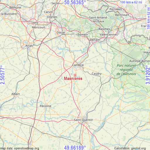
Masnières GPS coordinates[2]
50° 6' 53.604" North, 3° 12' 32.004" East
| Map corner | latitude | longitude |
|---|---|---|
| Upper-left | 50.56365°, | 2.50577° |
| Center: | 50.11489°, | 3.20889° |
| Lower-right: | 49.66189°, | 3.91202° |
| Map W x H: | 100.3×100.3 km | = 62.3×62.3mi |
| max Lat: | 51.07786° ⇑5.7% North |
| Masnières: | 50.11489° |
| min Lat: | ⇓94.3% South 41.3874° |
| min Long | Masnières | max Long |
| -5.08615° | 3.20889° | 9.52242° |
| W 60.7%⇐ | ⇒39.3% E |
Elevation
Elevation of Masnières is 69 m = 226 ft, and this is 124.7 m = 409 ft below average elevation for this country.
| Max E: |
2333 m = 7654 ft | 74.1% |
| Avg. | 193.7 m = 635 ft | |
| Masnières | 69 m = 226 ft | |
Min E: |
-1 m = -3 ft | 25.9% |
See also: France elevation on elevation.city.
Geographical zone
Masnières is located in North temperate zone (between Tropic of Cancer and the Arctic Circle). Distance of this North polar circle is 1828.9 km =1136.4 mi to North.| Distance of | km | miles | from Masnières |
|---|---|---|---|
| North Pole | 4434.8 | 2755.7 | to North |
| Arctic Circle | 1828.9 | 1136.4 | to North |
| Tropic Cancer | 2966.3 | 1843.2 | to South |
| Equator | 5572.3 | 3462.5 | to South |


Nearby cities:
15 places around Masnières: (largest is in red/bold)
• Awoingt
6.9 km =4.3 mi,  48°
48°
• Cambrai
7 km =4.3 mi,  15°
15°
• Esnes
7.6 km =4.7 mi,  101°
101°
• Fontaine-Notre-Dame
6.8 km =4.2 mi,  327°
327°
• Gouzeaucourt
8.9 km =5.5 mi,  222°
222°
• Graincourt-lès-Havrincourt
8 km =5 mi,  296°
296°
• Honnecourt-sur-Escaut
9.1 km =5.7 mi,  184°
184°
• Les Rues-des-Vignes
3 km =1.9 mi,  135°
135°
• Marcoing
2.6 km =1.6 mi,  285°
285°
• Neuville-Saint-Rémy
8 km =5 mi,  7°
7°
• Niergnies
5 km =3.1 mi,  42°
42°
• Noyelles-sur-Escaut
2.7 km =1.7 mi,  318°
318°
• Proville
5.2 km =3.2 mi,  357°
357°
• Raillencourt-Sainte-Olle
8.2 km =5.1 mi,  338°
338°
• Rumilly-en-Cambrésis
1.5 km =0.9 mi,  27°
27°
Sources, notices
• [Note1] Compared only with cities in France existing in our database
• [Src1] Map data: © OpenStreetMap contributors (CC-BY-SA)
• [Src2] Other city data from geonames.org with taken over terms of usage.
• [Src3] Geographical zone / Annual Mean Temperature by Robert A. Rohde @ Wikipedia
