Messey-sur-Grosne geodata
Messey-sur-Grosne (Bourgogne-Franche-Comté) is a populated place; located in France in Europe/Paris (GMT+2) time zone. With population of 636 people, there are 12726 cities with bigger population in this country. Compared to other cities in France, 58.8% of cities are located further ↑North; 74.2% of cities are located further ←West and 63.8% of cities have lower elevation than Messey-sur-Grosne. Note1
Administrative division(s):
- Level 1: Bourgogne-Franche-Comté
- Level 2: Département de Saône-et-Loire
- Level 3: Arrondissement de Chalon-sur-Saône
- Level 4: Messey-sur-Grosne


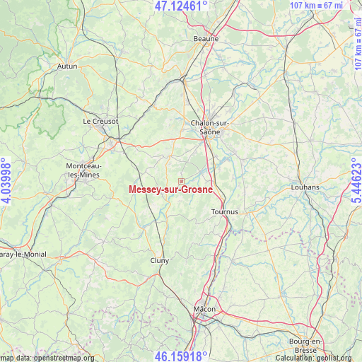
Messey-sur-Grosne GPS coordinates[2]
46° 38' 38.58" North, 4° 44' 35.16" East
| Map corner | latitude | longitude |
|---|---|---|
| Upper-left | 47.12461°, | 4.03998° |
| Center: | 46.64405°, | 4.7431° |
| Lower-right: | 46.15918°, | 5.44623° |
| Map W x H: | 107.3×107.3 km | = 66.7×66.7mi |
| max Lat: | 51.07786° ⇑58.8% North |
| Messey-sur-Grosne: | 46.64405° |
| min Lat: | ⇓41.2% South 41.3874° |
| min Long | Messey-sur-Gros | max Long |
| -5.08615° | 4.7431° | 9.52242° |
| W 74.2%⇐ | ⇒25.8% E |
Elevation
Elevation of Messey-sur-Grosne is 188 m = 617 ft, and this is 5.7 m = 19 ft below average elevation for this country.
| Max E: |
2333 m = 7654 ft | 36.2% |
| Avg. | 193.7 m = 635 ft | |
| Messey-sur-Grosne | 188 m = 617 ft | |
Min E: |
-1 m = -3 ft | 63.8% |
See also: France elevation on elevation.city.
Geographical zone
Messey-sur-Grosne is located in North temperate zone (between Tropic of Cancer and the Arctic Circle). Distance of this North polar circle is 2214.8 km =1376.2 mi to North.| Distance of | km | miles | from Messey-sur-Grosne |
|---|---|---|---|
| North Pole | 4820.7 | 2995.4 | to North |
| Arctic Circle | 2214.8 | 1376.2 | to North |
| Tropic Cancer | 2580.4 | 1603.4 | to South |
| Equator | 5186.3 | 3222.6 | to South |


Nearby cities:
15 places around Messey-sur-Grosne: (largest is in red/bold)
• Boyer
12.2 km =7.6 mi,  118°
118°
• Buxy
8.3 km =5.2 mi,  339°
339°
• Givry
15.3 km =9.5 mi,  359°
359°
• La Charmée
9.4 km =5.8 mi,  25°
25°
• Laives
7.7 km =4.8 mi,  89°
89°
• Moroges
12.9 km =8 mi, 336°
• Nanton
6.2 km =3.9 mi, 115°
• Saint-Cyr
12 km =7.5 mi,  69°
69°
• Saint-Désert
12.5 km =7.8 mi,  348°
348°
• Saint-Gengoux-le-National
7 km =4.3 mi,  242°
242°
• Saint-Rémy
15.2 km =9.4 mi, 28°
• Sennecey-le-Grand
9.5 km =5.9 mi, 91°
• Sevrey
12.8 km =8 mi,  35°
35°
• Tournus
15.1 km =9.4 mi, 124°
• Varennes-le-Grand
12.7 km =7.9 mi,  49°
49°
Sources, notices
• [Note1] Compared only with cities in France existing in our database
• [Src1] Map data: © OpenStreetMap contributors (CC-BY-SA)
• [Src2] Other city data from geonames.org with taken over terms of usage.
• [Src3] Geographical zone / Annual Mean Temperature by Robert A. Rohde @ Wikipedia
