Nanton geodata
Nanton (Bourgogne-Franche-Comté) is a populated place; located in France in Europe/Paris (GMT+2) time zone. With population of 587 people, there are 13526 cities with bigger population in this country. Compared to other cities in France, 59.1% of cities are located further ↑North; 75.3% of cities are located further ←West and 68% of cities have lower elevation than Nanton. Note1
Administrative division(s):
- Level 1: Bourgogne-Franche-Comté
- Level 2: Département de Saône-et-Loire
- Level 3: Arrondissement de Chalon-sur-Saône
- Level 4: Nanton


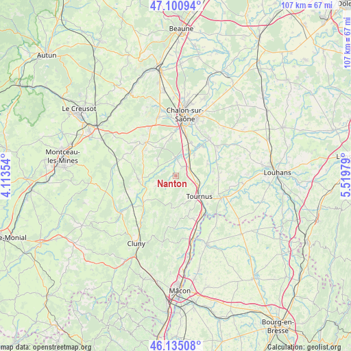
Nanton GPS coordinates[2]
46° 37' 12.576" North, 4° 48' 59.976" East
| Map corner | latitude | longitude |
|---|---|---|
| Upper-left | 47.10094°, | 4.11354° |
| Center: | 46.62016°, | 4.81666° |
| Lower-right: | 46.13508°, | 5.51979° |
| Map W x H: | 107.4×107.4 km | = 66.7×66.7mi |
| max Lat: | 51.07786° ⇑59.1% North |
| Nanton: | 46.62016° |
| min Lat: | ⇓40.9% South 41.3874° |
| min Long | Nanton | max Long |
| -5.08615° | 4.81666° | 9.52242° |
| W 75.3%⇐ | ⇒24.7% E |
Elevation
Elevation of Nanton is 209 m = 686 ft, and this is 15.3 m = 50 ft above average elevation for this country.
| Max E: |
2333 m = 7654 ft | 32% |
| Nanton | 209 m 686 ft | |
| Avg. | 193.7 m = 635 ft | |
Min E: |
-1 m = -3 ft | 68% |
See also: France elevation on elevation.city.
Geographical zone
Nanton is located in North temperate zone (between Tropic of Cancer and the Arctic Circle). Distance of this North polar circle is 2217.5 km =1377.9 mi to North.| Distance of | km | miles | from Nanton |
|---|---|---|---|
| North Pole | 4823.4 | 2997.1 | to North |
| Arctic Circle | 2217.5 | 1377.9 | to North |
| Tropic Cancer | 2577.8 | 1601.8 | to South |
| Equator | 5183.7 | 3221 | to South |


Nearby cities:
15 places around Nanton: (largest is in red/bold)
• Boyer
6 km =3.7 mi,  121°
121°
• Gigny-sur-Saône
10.9 km =6.8 mi,  64°
64°
• La Charmée
11.2 km =7 mi,  351°
351°
• Lacrost
11.2 km =7 mi,  128°
128°
• Laives
3.4 km =2.1 mi,  38°
38°
• Messey-sur-Grosne
6.2 km =3.9 mi,  295°
295°
• Plottes
11 km =6.8 mi,  156°
156°
• Préty
12.9 km =8 mi, 131°
• Saint-Cyr
8.9 km =5.5 mi, 38°
• Saint-Gengoux-le-National
11.8 km =7.3 mi,  267°
267°
• Sennecey-le-Grand
4.5 km =2.8 mi, 58°
• Sevrey
13.3 km =8.3 mi,  7°
7°
• Simandre
13.1 km =8.1 mi,  88°
88°
• Tournus
9 km =5.6 mi, 130°
• Varennes-le-Grand
11.7 km =7.3 mi,  19°
19°
Sources, notices
• [Note1] Compared only with cities in France existing in our database
• [Src1] Map data: © OpenStreetMap contributors (CC-BY-SA)
• [Src2] Other city data from geonames.org with taken over terms of usage.
• [Src3] Geographical zone / Annual Mean Temperature by Robert A. Rohde @ Wikipedia
