Saulgé geodata
Saulgé (Nouvelle-Aquitaine) is a populated place; located in France in Europe/Paris (GMT+2) time zone. With population of 1,075 people, there are 8295 cities with bigger population in this country. Compared to other cities in France, 61.3% of cities are located further ↑North; 70% of cities are located further →East and 61.5% of cities have higher elevation than Saulgé. Note1
Administrative division(s):
- Level 1: Nouvelle-Aquitaine
- Level 2: Vienne
- Level 3: Arrondissement de Montmorillon
- Level 4: Saulgé


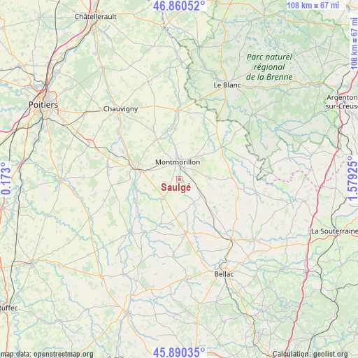
Saulgé GPS coordinates[2]
46° 22' 39.324" North, 0° 52' 34.068" East
| Map corner | latitude | longitude |
|---|---|---|
| Upper-left | 46.86052°, | 0.173° |
| Center: | 46.37759°, | 0.87613° |
| Lower-right: | 45.89035°, | 1.57925° |
| Map W x H: | 107.9×107.9 km | = 67×67mi |
| max Lat: | 51.07786° ⇑61.3% North |
| Saulgé: | 46.37759° |
| min Lat: | ⇓38.7% South 41.3874° |
| min Long | Saulgé | max Long |
| -5.08615° | 0.87613° | 9.52242° |
| W 30%⇐ | ⇒70% E |
Elevation
Elevation of Saulgé is 98 m = 322 ft, and this is 95.7 m = 314 ft below average elevation for this country.
| Max E: |
2333 m = 7654 ft | 61.5% |
| Avg. | 193.7 m = 635 ft | |
| Saulgé | 98 m = 322 ft | |
Min E: |
-1 m = -3 ft | 38.5% |
See also: France elevation on elevation.city.
Geographical zone
Saulgé is located in North temperate zone (between Tropic of Cancer and the Arctic Circle). Distance of this North polar circle is 2244.5 km =1394.7 mi to North.| Distance of | km | miles | from Saulgé |
|---|---|---|---|
| North Pole | 4850.4 | 3013.9 | to North |
| Arctic Circle | 2244.5 | 1394.7 | to North |
| Tropic Cancer | 2550.8 | 1585 | to South |
| Equator | 5156.7 | 3204.2 | to South |


Nearby cities:
15 places around Saulgé: (largest is in red/bold)
• Adriers
14.6 km =9.1 mi,  203°
203°
• Antigny
17.6 km =10.9 mi,  354°
354°
• Brigueil-le-Chantre
16.3 km =10.1 mi,  82°
82°
• Bussière-Poitevine
16 km =9.9 mi,  172°
172°
• Civaux
17.7 km =11 mi,  294°
294°
• Gouex
14.3 km =8.9 mi,  265°
265°
• La Trimouille
16.1 km =10 mi,  51°
51°
• Lathus-Saint-Rémy
7.9 km =4.9 mi,  127°
127°
• Leignes-sur-Fontaine
16.2 km =10.1 mi,  331°
331°
• Lussac-les-Châteaux
12.1 km =7.5 mi,  283°
283°
• Mazerolles
15.1 km =9.4 mi, 281°
• Montmorillon
5.5 km =3.4 mi, 354°
• Persac
13.5 km =8.4 mi,  254°
254°
• Queaux
17 km =10.6 mi, 250°
• Sillars
9.5 km =5.9 mi,  299°
299°
Sources, notices
• [Note1] Compared only with cities in France existing in our database
• [Src1] Map data: © OpenStreetMap contributors (CC-BY-SA)
• [Src2] Other city data from geonames.org with taken over terms of usage.
• [Src3] Geographical zone / Annual Mean Temperature by Robert A. Rohde @ Wikipedia
