Mauzac-et-Grand-Castang geodata
Mauzac-et-Grand-Castang (Nouvelle-Aquitaine) is a populated place; located in France in Europe/Paris (GMT+2) time zone. With population of 905 people, there are 9610 cities with bigger population in this country. Compared to other cities in France, 80.8% of cities are located further ↑North; 70.7% of cities are located further →East and 53.8% of cities have higher elevation than Mauzac-et-Grand-Castang. Note1
Administrative division(s):
- Level 1: Nouvelle-Aquitaine
- Level 2: Dordogne
- Level 3: Arrondissement de Bergerac
- Level 4: Mauzac-et-Grand-Castang
Current local time in Mauzac-et-Grand-Castang:
01:14 PM, SaturdayDifference from your time zone: hours


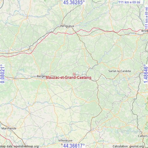
Mauzac-et-Grand-Castang GPS coordinates[2]
44° 52' 0.012" North, 0° 46' 59.988" East
| Map corner | latitude | longitude |
|---|---|---|
| Upper-left | 45.36285°, | 0.08021° |
| Center: | 44.86667°, | 0.78333° |
| Lower-right: | 44.36617°, | 1.48646° |
| Map W x H: | 110.8×110.8 km | = 68.8×68.8mi |
| max Lat: | 51.07786° ⇑80.8% North |
| Mauzac-et-Grand-Castang: | 44.86667° |
| min Lat: | ⇓19.2% South 41.3874° |
| min Long | Mauzac-et-Grand | max Long |
| -5.08615° | 0.78333° | 9.52242° |
| W 29.3%⇐ | ⇒70.7% E |
Elevation
Elevation of Mauzac-et-Grand-Castang is 120 m = 394 ft, and this is 73.7 m = 242 ft below average elevation for this country.
| Max E: |
2333 m = 7654 ft | 53.8% |
| Avg. | 193.7 m = 635 ft | |
| Mauzac-et-Grand-Castang | 120 m = 394 ft | |
Min E: |
-1 m = -3 ft | 46.2% |
See also: France elevation on elevation.city.
Geographical zone
Mauzac-et-Grand-Castang is located in North temperate zone (between Tropic of Cancer and the Arctic Circle). Distance of this Northern Tropic circle is 2382.8 km =1480.6 mi to South.| Distance of | km | miles | from Mauzac-et-Grand-Castang |
|---|---|---|---|
| North Pole | 5018.4 | 3118.3 | to North |
| Arctic Circle | 2412.5 | 1499.1 | to North |
| Tropic Cancer | 2382.8 | 1480.6 | to South |
| Equator | 4988.7 | 3099.8 | to South |


Nearby cities:
15 places around Mauzac-et-Grand-Castang: (largest is in red/bold)
• Beaumont-du-Périgord
11.2 km =7 mi,  185°
185°
• Cendrieux
14.8 km =9.2 mi,  12°
12°
• Coux-et-Bigaroque
15.4 km =9.6 mi,  103°
103°
• Couze-et-Saint-Front
7.5 km =4.7 mi,  235°
235°
• Lalinde
5.4 km =3.4 mi,  230°
230°
• Lamonzie-Montastruc
15.3 km =9.5 mi,  282°
282°
• Lanquais
10.1 km =6.3 mi, 241°
• Le Bugue
12.7 km =7.9 mi,  63°
63°
• Le Buisson-de-Cadouin
10.7 km =6.6 mi, 100°
• Mouleydier
14.7 km =9.1 mi,  265°
265°
• Saint-Capraise-de-Lalinde
10.5 km =6.5 mi,  255°
255°
• Saint-Sauveur
15.5 km =9.6 mi, 270°
• Sainte-Alvère
9.6 km =6 mi,  15°
15°
• Siorac-en-Périgord
16.8 km =10.4 mi,  107°
107°
• Trémolat
3.8 km =2.4 mi,  76°
76°
Sources, notices
• [Note1] Compared only with cities in France existing in our database
• [Src1] Map data: © OpenStreetMap contributors (CC-BY-SA)
• [Src2] Other city data from geonames.org with taken over terms of usage.
• [Src3] Geographical zone / Annual Mean Temperature by Robert A. Rohde @ Wikipedia
