Sainte-Alvère geodata
Sainte-Alvère (Nouvelle-Aquitaine) is a populated place; located in France in Europe/Paris (GMT+2) time zone. With population of 900 people, there are 9657 cities with bigger population in this country. Compared to other cities in France, 80.1% of cities are located further ↑North; 70.4% of cities are located further →East and 64% of cities have lower elevation than Sainte-Alvère. Note1
Administrative division(s):
- Level 1: Nouvelle-Aquitaine
- Level 2: Dordogne
- Level 3: Arrondissement de Périgueux
- Level 4: Val de Louyre et Caudeau


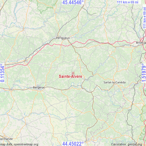
Sainte-Alvère GPS coordinates[2]
44° 57' 0" North, 0° 49' 0.012" East
| Map corner | latitude | longitude |
|---|---|---|
| Upper-left | 45.44546°, | 0.11354° |
| Center: | 44.95°, | 0.81667° |
| Lower-right: | 44.45022°, | 1.51979° |
| Map W x H: | 110.7×110.7 km | = 68.8×68.8mi |
| max Lat: | 51.07786° ⇑80.1% North |
| Sainte-Alvère: | 44.95° |
| min Lat: | ⇓19.9% South 41.3874° |
| min Long | Sainte-Alvère | max Long |
| -5.08615° | 0.81667° | 9.52242° |
| W 29.6%⇐ | ⇒70.4% E |
Elevation
Elevation of Sainte-Alvère is 189 m = 620 ft, and this is 4.7 m = 15 ft below average elevation for this country.
| Max E: |
2333 m = 7654 ft | 36% |
| Avg. | 193.7 m = 635 ft | |
| Sainte-Alvère | 189 m = 620 ft | |
Min E: |
-1 m = -3 ft | 64% |
See also: France elevation on elevation.city.
Geographical zone
Sainte-Alvère is located in North temperate zone (between Tropic of Cancer and the Arctic Circle). Distance of this Northern Tropic circle is 2392.1 km =1486.4 mi to South.| Distance of | km | miles | from Sainte-Alvère |
|---|---|---|---|
| North Pole | 5009.1 | 3112.5 | to North |
| Arctic Circle | 2403.2 | 1493.3 | to North |
| Tropic Cancer | 2392.1 | 1486.4 | to South |
| Equator | 4998 | 3105.6 | to South |


Nearby cities:
15 places around Sainte-Alvère: (largest is in red/bold)
• Cendrieux
5.2 km =3.2 mi,  6°
6°
• Coux-et-Bigaroque
17.9 km =11.1 mi,  136°
136°
• Couze-et-Saint-Front
16.1 km =10 mi,  213°
213°
• La Douze
13 km =8.1 mi,  16°
16°
• Lacropte
9.7 km =6 mi, 6°
• Lalinde
14.3 km =8.9 mi, 208°
• Le Bugue
9.4 km =5.8 mi,  111°
111°
• Le Buisson-de-Cadouin
13.6 km =8.5 mi, 144°
• Les Eyzies-de-Tayac-Sireuil
15.6 km =9.7 mi,  95°
95°
• Marsaneix
16.8 km =10.4 mi,  351°
351°
• Mauzac-et-Grand-Castang
9.6 km =6 mi,  195°
195°
• Rouffignac-Saint-Cernin-de-Reilhac
16.2 km =10.1 mi,  46°
46°
• Saint-Capraise-de-Lalinde
17.5 km =10.9 mi,  226°
226°
• Trémolat
8.4 km =5.2 mi,  172°
172°
• Vergt
11.5 km =7.1 mi,  317°
317°
Sources, notices
• [Note1] Compared only with cities in France existing in our database
• [Src1] Map data: © OpenStreetMap contributors (CC-BY-SA)
• [Src2] Other city data from geonames.org with taken over terms of usage.
• [Src3] Geographical zone / Annual Mean Temperature by Robert A. Rohde @ Wikipedia
