Castelnau-Rivière-Basse geodata
Castelnau-Rivière-Basse (Occitanie) is a populated place; located in France in Europe/Paris (GMT+2) time zone. With population of 693 people, there are 11901 cities with bigger population in this country. Compared to other cities in France, 92.1% of cities are located further ↑North; 78.3% of cities are located further →East and 73.3% of cities have lower elevation than Castelnau-Rivière-Basse. Note1
Administrative division(s):
- Level 1: Occitanie
- Level 2: Département des Hautes-Pyrénées
- Level 3: Arrondissement de Tarbes
- Level 4: Castelnau-Rivière-Basse
Current local time in Castelnau-Rivière-Basse:
02:23 PM, SaturdayDifference from your time zone: hours


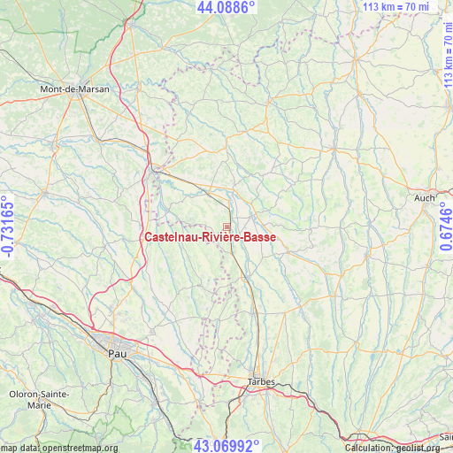
Castelnau-Rivière-Basse GPS coordinates[2]
43° 34' 53.076" North, 0° 1' 42.708" West
| Map corner | latitude | longitude |
|---|---|---|
| Upper-left | 44.0886°, | -0.73165° |
| Center: | 43.58141°, | -0.02853° |
| Lower-right: | 43.06992°, | 0.6746° |
| Map W x H: | 113.3×113.3 km | = 70.4×70.4mi |
| max Lat: | 51.07786° ⇑92.1% North |
| Castelnau-Rivière-Basse: | 43.58141° |
| min Lat: | ⇓7.9% South 41.3874° |
| min Long | Castelnau-Rivi� | max Long |
| -5.08615° | -0.02853° | 9.52242° |
| W 21.7%⇐ | ⇒78.3% E |
Elevation
Elevation of Castelnau-Rivière-Basse is 238 m = 781 ft, and this is 44.3 m = 145 ft above average elevation for this country.
| Max E: |
2333 m = 7654 ft | 26.7% |
| Castelnau-Rivière-Basse | 238 m 781 ft | |
| Avg. | 193.7 m = 635 ft | |
Min E: |
-1 m = -3 ft | 73.3% |
See also: France elevation on elevation.city.
Geographical zone
Castelnau-Rivière-Basse is located in North temperate zone (between Tropic of Cancer and the Arctic Circle). Distance of this Northern Tropic circle is 2239.9 km =1391.8 mi to South.| Distance of | km | miles | from Castelnau-Rivière-Basse |
|---|---|---|---|
| North Pole | 5161.3 | 3207.1 | to North |
| Arctic Circle | 2555.4 | 1587.9 | to North |
| Tropic Cancer | 2239.9 | 1391.8 | to South |
| Equator | 4845.8 | 3011 | to South |


Nearby cities:
15 places around Castelnau-Rivière-Basse: (largest is in red/bold)
• Aignan
15.8 km =9.8 mi,  35°
35°
• Barcelonne-du-Gers
21.5 km =13.4 mi,  309°
309°
• Beaumarchés
9 km =5.6 mi,  88°
88°
• Garlin
19.9 km =12.4 mi,  262°
262°
• Lembeye
15.7 km =9.8 mi,  201°
201°
• Madiran
3.9 km =2.4 mi,  206°
206°
• Marciac
16.6 km =10.3 mi,  112°
112°
• Maubourguet
13.6 km =8.5 mi,  157°
157°
• Nogaro
19.7 km =12.2 mi,  358°
358°
• Plaisance
6.5 km =4 mi,  67°
67°
• Riscle
9.5 km =5.9 mi,  330°
330°
• Sainte-Marie-de-Gosse
16.9 km =10.5 mi, 258°
• Sévignacq
24.1 km =15 mi,  232°
232°
• Vic-en-Bigorre
22.7 km =14.1 mi, 162°
• Viella
9.1 km =5.7 mi,  282°
282°
Sources, notices
• [Note1] Compared only with cities in France existing in our database
• [Src1] Map data: © OpenStreetMap contributors (CC-BY-SA)
• [Src2] Other city data from geonames.org with taken over terms of usage.
• [Src3] Geographical zone / Annual Mean Temperature by Robert A. Rohde @ Wikipedia
