Massongy geodata
Massongy (Auvergne-Rhône-Alpes) is a populated place; located in France in Europe/Paris (GMT+2) time zone. With population of 1,273 people, there are 7156 cities with bigger population in this country. Compared to other cities in France, 62.1% of cities are located further ↑North; 90.5% of cities are located further ←West and 90% of cities have lower elevation than Massongy. Note1
Administrative division(s):
- Level 1: Auvergne-Rhône-Alpes
- Level 2: Haute-Savoie
- Level 3: Arrondissement de Thonon-les-Bains
- Level 4: Massongy


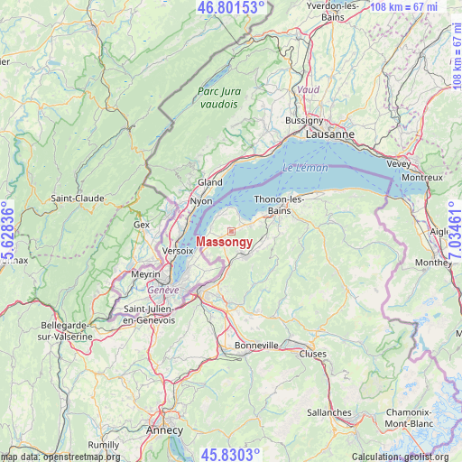
Massongy GPS coordinates[2]
46° 19' 5.052" North, 6° 19' 53.328" East
| Map corner | latitude | longitude |
|---|---|---|
| Upper-left | 46.80153°, | 5.62836° |
| Center: | 46.31807°, | 6.33148° |
| Lower-right: | 45.8303°, | 7.03461° |
| Map W x H: | 108×108 km | = 67.1×67.1mi |
| max Lat: | 51.07786° ⇑62.1% North |
| Massongy: | 46.31807° |
| min Lat: | ⇓37.9% South 41.3874° |
| min Long | Massongy | max Long |
| -5.08615° | 6.33148° | 9.52242° |
| W 90.5%⇐ | ⇒9.5% E |
Elevation
Elevation of Massongy is 425 m = 1394 ft, and this is 231.3 m = 759 ft above average elevation for this country.
| Max E: |
2333 m = 7654 ft | 10% |
| Massongy | 425 m 1394 ft | |
| Avg. | 193.7 m = 635 ft | |
Min E: |
-1 m = -3 ft | 90% |
See also: France elevation on elevation.city.
Geographical zone
Massongy is located in North temperate zone (between Tropic of Cancer and the Arctic Circle). Distance of this North polar circle is 2251.1 km =1398.8 mi to North.| Distance of | km | miles | from Massongy |
|---|---|---|---|
| North Pole | 4857 | 3018 | to North |
| Arctic Circle | 2251.1 | 1398.8 | to North |
| Tropic Cancer | 2544.2 | 1580.9 | to South |
| Equator | 5150.1 | 3200.1 | to South |


Nearby cities:
15 places around Massongy: (largest is in red/bold)
• Ballaison
2.2 km =1.4 mi,  187°
187°
• Bons-en-Chablais
6.7 km =4.2 mi,  152°
152°
• Brenthonne
7.2 km =4.5 mi,  135°
135°
• Chens-sur-Léman
4.7 km =2.9 mi,  278°
278°
• Douvaine
2.6 km =1.6 mi,  236°
236°
• Excenevex
4.2 km =2.6 mi,  21°
21°
• Fessy
7.9 km =4.9 mi,  128°
128°
• Loisin
3.3 km =2.1 mi,  209°
209°
• Lully
7.5 km =4.7 mi,  119°
119°
• Machilly
7.5 km =4.7 mi,  179°
179°
• Margencel
6.9 km =4.3 mi,  67°
67°
• Messery
4.7 km =2.9 mi,  319°
319°
• Sciez
4.3 km =2.7 mi, 68°
• Veigy
7.7 km =4.8 mi,  223°
223°
• Yvoire
5.4 km =3.4 mi,  358°
358°
Sources, notices
• [Note1] Compared only with cities in France existing in our database
• [Src1] Map data: © OpenStreetMap contributors (CC-BY-SA)
• [Src2] Other city data from geonames.org with taken over terms of usage.
• [Src3] Geographical zone / Annual Mean Temperature by Robert A. Rohde @ Wikipedia
