Douvaine geodata
Douvaine (Auvergne-Rhône-Alpes) is a populated place; located in France in Europe/Paris (GMT+2) time zone. With population of 4,278 people, there are 2304 cities with bigger population in this country. Compared to other cities in France, 62.2% of cities are located further ↑North; 90.2% of cities are located further ←West and 90.2% of cities have lower elevation than Douvaine. Note1
Administrative division(s):
- Level 1: Auvergne-Rhône-Alpes
- Level 2: Haute-Savoie
- Level 3: Arrondissement de Thonon-les-Bains
- Level 4: Douvaine


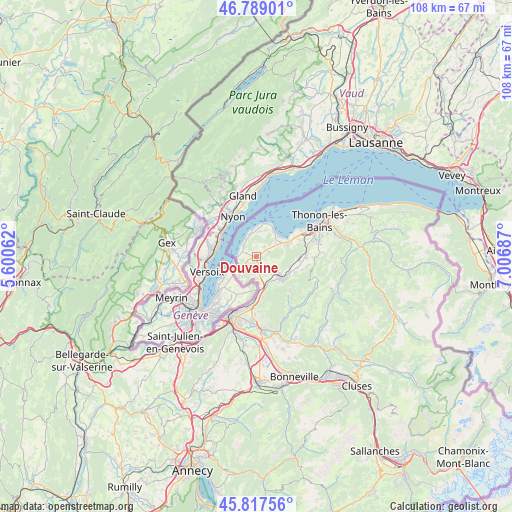
Douvaine GPS coordinates[2]
46° 18' 19.584" North, 6° 18' 13.5" East
| Map corner | latitude | longitude |
|---|---|---|
| Upper-left | 46.78901°, | 5.60062° |
| Center: | 46.30544°, | 6.30375° |
| Lower-right: | 45.81756°, | 7.00687° |
| Map W x H: | 108×108 km | = 67.1×67.1mi |
| max Lat: | 51.07786° ⇑62.2% North |
| Douvaine: | 46.30544° |
| min Lat: | ⇓37.8% South 41.3874° |
| min Long | Douvaine | max Long |
| -5.08615° | 6.30375° | 9.52242° |
| W 90.2%⇐ | ⇒9.8% E |
Elevation
Elevation of Douvaine is 431 m = 1414 ft, and this is 237.3 m = 779 ft above average elevation for this country.
| Max E: |
2333 m = 7654 ft | 9.8% |
| Douvaine | 431 m 1414 ft | |
| Avg. | 193.7 m = 635 ft | |
Min E: |
-1 m = -3 ft | 90.2% |
See also: France elevation on elevation.city.
Geographical zone
Douvaine is located in North temperate zone (between Tropic of Cancer and the Arctic Circle). Distance of this North polar circle is 2252.5 km =1399.6 mi to North.| Distance of | km | miles | from Douvaine |
|---|---|---|---|
| North Pole | 4858.4 | 3018.9 | to North |
| Arctic Circle | 2252.5 | 1399.6 | to North |
| Tropic Cancer | 2542.8 | 1580 | to South |
| Equator | 5148.7 | 3199.3 | to South |


Nearby cities:
15 places around Douvaine: (largest is in red/bold)
• Ballaison
2 km =1.2 mi,  113°
113°
• Bons-en-Chablais
6.9 km =4.3 mi,  131°
131°
• Brenthonne
8.1 km =5 mi,  117°
117°
• Chens-sur-Léman
3.3 km =2.1 mi,  310°
310°
• Excenevex
6.4 km =4 mi,  34°
34°
• Fessy
9.1 km =5.7 mi, 112°
• Loisin
1.5 km =0.9 mi,  161°
161°
• Lully
9 km =5.6 mi,  104°
104°
• Machilly
6.5 km =4 mi, 160°
• Massongy
2.6 km =1.6 mi,  56°
56°
• Messery
5.1 km =3.2 mi,  348°
348°
• Saint-Cergues
8.5 km =5.3 mi,  171°
171°
• Sciez
6.9 km =4.3 mi, 64°
• Veigy
5.2 km =3.2 mi,  216°
216°
• Yvoire
7.1 km =4.4 mi,  16°
16°
Sources, notices
• [Note1] Compared only with cities in France existing in our database
• [Src1] Map data: © OpenStreetMap contributors (CC-BY-SA)
• [Src2] Other city data from geonames.org with taken over terms of usage.
• [Src3] Geographical zone / Annual Mean Temperature by Robert A. Rohde @ Wikipedia
