Martigné-Ferchaud geodata
Martigné-Ferchaud (Brittany) is a populated place; located in France in Europe/Paris (GMT+2) time zone. With population of 2,619 people, there are 3722 cities with bigger population in this country. Compared to other cities in France, 56.3% of cities are located further ↓South; 90.9% of cities are located further →East and 59.4% of cities have higher elevation than Martigné-Ferchaud. Note1
Administrative division(s):
- Level 1: Brittany
- Level 2: Département d'Ille-et-Vilaine
- Level 3: Arrondissement de Fougères-Vitré
- Level 4: Martigné-Ferchaud


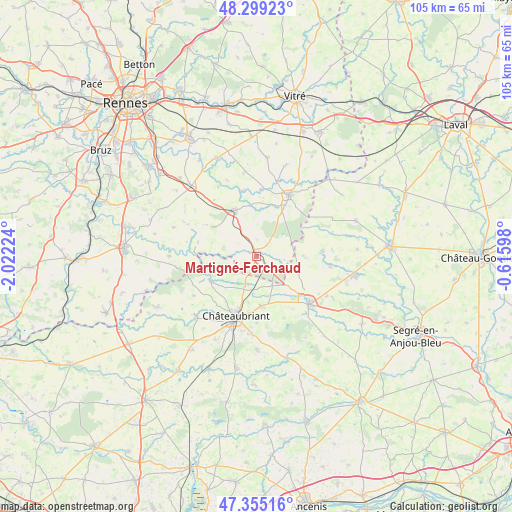
Martigné-Ferchaud GPS coordinates[2]
47° 49' 45.624" North, 1° 19' 8.796" West
| Map corner | latitude | longitude |
|---|---|---|
| Upper-left | 48.29923°, | -2.02224° |
| Center: | 47.82934°, | -1.31911° |
| Lower-right: | 47.35516°, | -0.61598° |
| Map W x H: | 105×105 km | = 65.2×65.2mi |
| max Lat: | 51.07786° ⇑43.7% North |
| Martigné-Ferchaud: | 47.82934° |
| min Lat: | ⇓56.3% South 41.3874° |
| min Long | Martigné-Ferch | max Long |
| -5.08615° | -1.31911° | 9.52242° |
| W 9.1%⇐ | ⇒90.9% E |
Elevation
Elevation of Martigné-Ferchaud is 104 m = 341 ft, and this is 89.7 m = 294 ft below average elevation for this country.
| Max E: |
2333 m = 7654 ft | 59.4% |
| Avg. | 193.7 m = 635 ft | |
| Martigné-Ferchaud | 104 m = 341 ft | |
Min E: |
-1 m = -3 ft | 40.6% |
See also: France elevation on elevation.city.
Geographical zone
Martigné-Ferchaud is located in North temperate zone (between Tropic of Cancer and the Arctic Circle). Distance of this North polar circle is 2083 km =1294.3 mi to North.| Distance of | km | miles | from Martigné-Ferchaud |
|---|---|---|---|
| North Pole | 4688.9 | 2913.5 | to North |
| Arctic Circle | 2083 | 1294.3 | to North |
| Tropic Cancer | 2712.2 | 1685.3 | to South |
| Equator | 5318.1 | 3304.5 | to South |


Nearby cities:
15 places around Martigné-Ferchaud: (largest is in red/bold)
• Châteaubriant
13.2 km =8.2 mi,  198°
198°
• Coësmes
10.9 km =6.8 mi,  303°
303°
• Fercé
8.2 km =5.1 mi,  242°
242°
• La Guerche-de-Bretagne
14.1 km =8.8 mi,  28°
28°
• Le Theil-de-Bretagne
13 km =8.1 mi,  320°
320°
• Marcillé-Robert
13.7 km =8.5 mi,  346°
346°
• Noyal-sur-Brutz
6.4 km =4 mi, 198°
• Rannée
12 km =7.5 mi, 28°
• Retiers
10.4 km =6.5 mi,  334°
334°
• Rougé
10.9 km =6.8 mi, 242°
• Saint-Aignan-sur-Roë
13.6 km =8.5 mi,  84°
84°
• Soudan
10.2 km =6.3 mi,  174°
174°
• Thourie
12.4 km =7.7 mi,  283°
283°
• Villepot
6.7 km =4.2 mi,  152°
152°
• Visseiche
14.1 km =8.8 mi,  5°
5°
Sources, notices
• [Note1] Compared only with cities in France existing in our database
• [Src1] Map data: © OpenStreetMap contributors (CC-BY-SA)
• [Src2] Other city data from geonames.org with taken over terms of usage.
• [Src3] Geographical zone / Annual Mean Temperature by Robert A. Rohde @ Wikipedia
